Mountains and Their Origin
A CHAPTER on mountains will not be an inappropriate introduction to that part of the world’s history on which we are now entering, when the great inequalities of the earth’s surface began to make their appearance; and before giving any special account of the geological succession in Europe, I will say something of the formation of mountains in general, and of the men whose investigations first gave us the clue to the intricacies of their structure. It has been the work of the nineteenth century to decipher the history of the mountains, to smooth out these wrinkles in the crust of the earth, to show that there was a time when they did not exist, to decide at least comparatively upon their age, and to detect the forces which have produced them.
But while I speak of the reconstructive labors of the geologist with so much confidence, because to my mind they reveal an intelligible coherence in the whole physical history of the world, yet I am well aware that there are many and wide gaps in our knowledge to be filled up. All the attempts to represent the appearance of the earth in past periods by means of geological maps are, of course, but approximations of the truth, and will compare with those of future times, when the phenomena are better understood, much as our present geographical maps, the result of repeated surveys and of the most accurate measurements, compare with those of the ancients.
Homer’s world was a flat expanse, surrounded by ocean, of which Greece was the centre. Asia Minor, the Ægean Islands, Egypt, part of Italy and Sicily, the Mediterranean and the Black Sea filled out and completed his map.
Hecatæus, the Greek historian and geographer, who lived more than five hundred years before Christ, had not enlarged it much. He was, to be sure, a voyager on the Mediterranean, and had an idea of the extent of Italy. Acquaintance with Phoenician merchants also had enlarged his knowledge of the world; Sardinia, Corsica, and Spain were known to him ; he was familiar with the Black and Red Seas; and though an indentation on his map in the neighborhood of the Caspian would seem to indicate that he was aware of the existence of this sea also, it is not otherwise marked.
Herodotus makes a considerable advance beyond his predecessors: the Caspian Sea has a place on his map ; Asia is sketched out, including the Persian Gulf with the large rivers pouring into it; and the course of the Ganges is traced, though he makes it flow east and empty into the Pacific, instead of turning southward and emptying into the Indian Ocean.
Eratosthenes, two centuries before Christ, is the first geographer who makes some attempt to determine the trend of the land and water, presenting a suggestion that the earth is broader in one direction than in the other. In his map, he adds also the geographical results derived from the expeditions of Alexander the Great.
Ptolemy, who flourished in Alexandria in the reign of Hadrian, is the next geographer of eminence, and he shows us something of Africa : for, in his time, the Phoenicians, in their commercial expeditions, had sailed far to the south, had reached the termination of Africa, with ocean lying all around it, and had seen the sun to the north of them. This last assertion, however, Ptolemy does not credit, and he is as skeptical of the open ocean surrounding the extremity of Africa as modern geographers and explorers have been of the existence of Kane's open Arctic Sea. He believes that what the Phoenician traders took to be the broad ocean must be part of an inland sea, corresponding to the Mediterranean, with which he was so familiar. His map includes also England, Ireland, and Scotland ; and his Ultima Thule is, no doubt, the Hebrides of our days.
Our present notions of the past periods of the world’s history probably bear about the same relation to the truth that these ancient geographical maps bear to the modern ones. But this should not discourage us, for, after all, those maps were in the main true as far as they went ; and as the ancient geographers were laying the foundation for all our modern knowledge of the present Conformation of the globe, so are the geologists of the nineteenth century preparing the ground for future investigators, whose work will be as far in advance of theirs as are the delineations of Carl Ritter, the great master of physical geography in our age, in advance of the map drawn by the old Alexandrian geographer. We shall have our geological explorers and discoverers in the lands and seas of past times, as we have had in the present, — our Columbuses, our Captain Cooks, our Livingstones in geology, as we have had in geography. There are undiscovered continents and rivers and inland seas in the past world to exercise the ingenuity, courage, and perseverance of men, after they shall have solved all the problems, sounded all the depths, and scaled all the heights of the present surface of the earth.
What has been done thus far is chiefly to classify the inequalities of the earth’s surface, and to detect the different causes which have produced them. Foldings of the earth’s crust, low hills, extensive plains, mountain-chains and narrow valleys, broad table-lands and wide valleys, local chimneys or volcanoes, river-beds, lake-basins, inland seas, — such are some of the phenomena which, disconnected as they seem at first glance, have nevertheless been brought under certain principles, and explained according to definite physical laws.
Formerly men looked upon the earth as a unit in time, as the result of one creative act, with all its outlines established from the beginning. It has been the work of modern science to show that its inequalities are not contemporaneous or simultaneous, but successive, including a law of growth, — that heat and cold, and the consequent expansion and contraction of its crust, have produced wrinkles and folds upon the surface, while constant oscillations, changes of level which are even now going on, have modified its conformation, and moulded its general outline through successive ages.
In thinking of the formation of the globe, we must at once free ourselves from the erroneous impression that the crust of the earth is a solid, steadfast foundation. So far from being inmoveable, it has been constantly heaving and falling; and if we are not impressed by its oscillations, it is because they are not so regular or so evident to our senses as the rise and fall of the sea. The disturbances of the ocean, and the periodical advance and retreat of its tides, are known to our daily experience ; we have seen it tossed into great billows by storms, or placid as a lake when undisturbed. But the crust of the earth also has had its storms, to which the tempests of the sea are as nothing, — which have thrown up mountain waves twenty thousand feet high, and fixed them where they stand, perpetual memorials of the convulsions that upheaved them. Conceive an ocean wave that should roll up for twenty thousand feet, and be petrified at its greatest height: the mountains are but the gigantic waves raised on the surface of the land by the geological tempests of past times. Besides these sudden storms of the earth’s surface, there have been its gradual upheavals and depressions, going on now as steadily as ever, and which may be compared to the regular action of the tides. These, also, have had their share in determining the outlines of the continents, the height of the lands, and the depth of the seas.
Leaving aside the more general phenomena, let us look now at the formation of mountains especially. I have stated in a previous article that the relative position of the stratified and unstratified rocks gives us the key to their comparative age. To explain this I must enter into some details respecting the arrangement of stratified deposits on mountainslopes and in mountain-chains, taking merely theoretical cases, however, to illustrate phenomena which we shall meet with repeatedly in actual facts, when studying special geological formations.
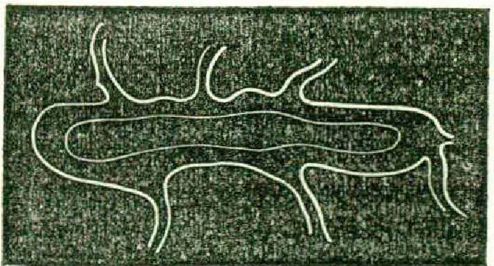
We have, for instance, in Figure 1, a central granite mountain, with a succession of stratified beds sloping against its sides, wliite at its base are deposited a number of horizontal beds which have evidently never been disturbed from the position in which they were originally accumulated. The reader will at once perceive the method by which the geologist decides upon the age of such a mountain. He finds the strata upon its slopes in regular superposition, the uppermost belonging, we will suppose, to the Triassic period; at its base he finds undisturbed horizontal deposits, also in regular superposition, belonging to the Jurassic and Cretaceous periods. Therefore, he argues. this mountain must have been uplifted after the Triassic and all preceding deposits were formed, since it has broken its way through them, and forced them out of their natural position: and it must have been previous to the Jurassic and Cretaceous deposits, since they have been accumulated peacefully at its base, and have undergone no suchperturbations.
The task of the geologist would be an easy one, if all the problems he has to deal with were as simple as the case I have presented here ; but the most cursory glance at the intricacies of mountainstructure will show us how difficult it is to trace the connection between the phenomena. We must not form an idea of ancient mountain-upheavals from existing active volcanoes, although the causes which produced them were, in a modified and limited sense, the same. Our present volcanic mountains are only chimneys, or narrow tunnels, as it were, pierced in the thickness of the earth’s surface, through which the molten lava pours out, flowing over the edges and down the sides and hardening upon the slopes, so as to form conical elevations. The mountain - ranges upheaved by ancient eruptions, on the contrary, are folds of the earth’s surface, produced by the cooling of a Comparatively thin crust upon a hot mass. The first effect of this cooling process would be to cause contractions; the next, to produce corresponding protrusions, — for, wherever such a shrinking and subsidence of the crust occurred, the consequent pressure upon the melted materials beneath must displace them and force them upward. W hile the crust continued so thin that these results could go on without very violent dislocations, — the materials within easily finding an outlet, if displaced, or merely lifting the surface without breaking through it,—the effect would be moderate elevations divided by corresponding depressions. We have seen this kind of action, during the earlier geological epochs, in the upheaval of the low hills in the United States, leading to the formation of the coal-basins.
On our return to the study of the American continent, we shall find in the Alleghany chain, occurring at a later period, between the Carboniferous and Triassic epochs, a. good illustration of the same kind of phenomena, though the action of the Plutonic agents was then much more powerful, owing to the greater thickness of the crust and the consequent increase of resistance. The folds forced upward in this chain by the subsidence of the surface are higher than any preceding elevations ; but they are nevertheless a suceession of parallel folds divided by corresponding depressions, nor does it seem that the displacement of the materials within the crust was so violent as to fracture it extensively.
Even so late as the formation of the Jura mountains, between the Jurassic and Cretaceous periods, the character of the upheaval is the same, though there are more cracks at right angles with the general trend of the chain, and here and there the masses below have broken through. But the chain, as a whole consists of a succession of parallel folds, forming long domes or arches, divided by longitudinal valleys. The valleys represent the subsidences of the crust; the domes are the corresponding protrusions resulting from these subsidences. The lines of gentle undulation in this chain, so striking in contrast to the rugged and abrupt character of the Alps immediately opposite, are the result of this mode of formation.
After the crust of the -earth had grown so thick, as it was, for instance, in the later Tertiary periods, when the Alps were uplifted, such an eruption could take place only by means of an immense force, and the extent of the fracture would be in proportion to the resistance opposed. It is hardly to be doubted, from the geological evidence already collected, that the whole mountain-range from "Western. Europe through the continent of Asia, including the Alps, the Caucasus, and the Himalayas, was raised at the same time. A convulsion that thus made a gigantic rent across two continents, giving egress to three such mountainranges, must have been accompanied by a thousand fractures and breaks in contrary directions. Such a pressure along so extensive a tract could not be equal everywhere ; the various thicknesses of the crust, the greater or less flexibility of the deposits, the direction of the pressure, would give rise to an infinite variety in the results; accordingly, instead of the long, even arches, such as characterize the earlier upheavals of the Alleghanies and the Jura, there are violent dislocations of the surface, cracks, rents, and fissures in all directions, transverse to the general trend of the upheaval, as well as parallel with it.
Leaving aside for the moment the more baffling and intricate problems of the lator mountain-formations, I will first endeavor to explain the simpler phenomena of the earlier upheavals.
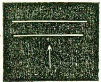
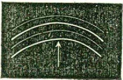
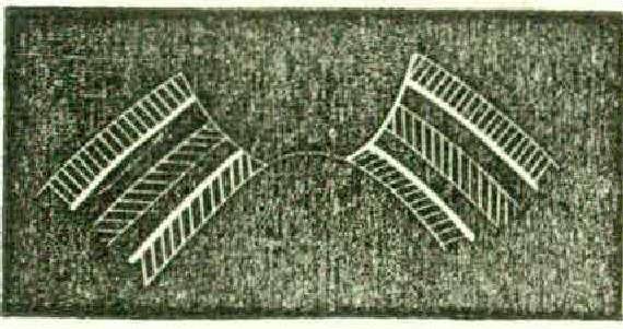
Suppose that the melted materials within the earth are forced up against a mass of stratified deposits, the direction of the pressure being perfectly vertical, as represented in Figure 2. Such a pressure, if not too violent, would simply lift the strata out of their horizontal position into an arch or dome, (as in Figure 3,) and if continued or repeated in immediate sequence, it would produce a number of such domes, like long billows following each other, such as we have in the Jura. But though this is the prevailing character of the range, there are many instances even here where an unequal pressure has caused a rent at right angles with the general direction of the upheaval; and one may trace the action of this unequal pressure, from the unbroken arch, where it has simply lifted the surface into a dome, to the granite crest, where the melted rock has forced its way out and crystallized between the broken beds that rest against its slopes.
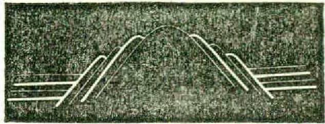
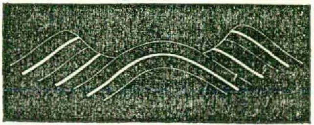
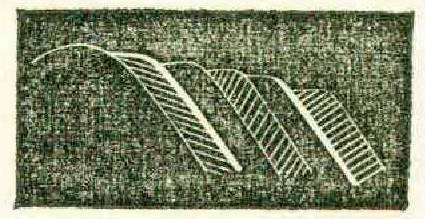
In other instances, the upper beds alone may have been cracked, while the continuity of the lower ones remains unbroken. In this case we have a longitudinal valley on the top of a mountain-range, lying between the two sides of the broken arch (as in Figure 4). Suppose, now, that there are also transverse cracks across such a longitudinal split, we have then a longitudinal valley with transverse valleys opening into it. There are many instances of this in the Alleghanies and in the Jura. Sometimes such transverse valleys are cut straight across, so that their openings face each other; but often the cracks have taken place at different points on the opposite sides, so that, in travelling through such a transverse valley, you turn to the right or left, as the case may be, where it enters the longitudinal valley, and follow that till you come to another transverse valley opening into it from the opposite side, through which you make your way out, thus crossing the chain in a zigzag course (as in Figure 5). Such valleys are often much narrower at some points than at others. There are even places in the Jura where a rent in the chain begins -with a mere crack, — a slit but just wide enough to admit the blade of a knife ; follow it for a while, and you may find it spreading gradually into a wider chasm, and finally expanding into a valley perhaps half a mile wide, or even wider.
By means of such cracks, rivers often pass through lofty mountain-chains, and when we come to the investigation of the glacial phenomena connected with the course of the Rhone, we shall find that river following the longitudinal valley which separates the northern and southern parts of the chain of the Alps till it comes to Martigny, -where it takes a sharp turn to the right through a transverse crack, flowing northward between walls fourteen thousand feet high, till it enters the Lake of Geneva, through which it passes, issuing at the other end, where it takes a southern direction. For a long time mountains were supposed to be the limitations of rivers, and old maps represent them always as flowing along the valleys without ever passing through the mountain-chains that divide them; but geology is fast correcting the errors of geography, and a map which represents merely the external features of a country, without reference to their structural relations, is no longer of any scientific value. ,
It is not, however, by rents in mountainchains alone, or by depressions between them, that valleys are produced ; they are often due to the unequal hardness of the beds raised, and to their greater or less liability to be worn away and disintegrated by the action of the rains. This inequality in the hardness of the rocks forming a mountain-range not only adds very much to the picturesquenees of outline, but also renders the landscape more varied through the greater or less fertility of the soil. On the hard rocks, where little soil can gather, there are only pines, or a low, dwarfed growth; but on the rocks of softer materials, more easily acted upon by the rain, a richer soil gathers, and there, in the midst of mountain-scenery, may be found the most fertile growth, the richest pasturage, the brightest flowers. Where such a patch of arable soil has a southern exposure on a mountain-side, we may have a most fertile vegetation at a great height and surrounded by the dark pine-forests. Many of the pastures on the Alps, to which from height to height the shepherds ascend with their flocks in the summer,— seeking the higher ones as the lower become dry and exhausted,— are due to such alternations in the character of the rocks.
In consequence of the influence of time, weather, atmospheric action of all kinds, the apparent relation of beds bas often become so completely reversed that it is exceedingly difficult to trace their original relation. Take, for instance, the following case. An eruption has upheaved the strata over a given surface in such a manner as to lift them into a mountain, cracking open the upper beds, but leaving the lower ones unbroken. We have then a valley on a mountain-summit between two crests resembling the one already shown in Figure 4. Such a narrow passage between two crests may be changed in the course of time to a wide expansive valley by the action of the rains, frosts, and other disintegrating agents, and the relative position of the strata forming its walls may seem to be entirely changed.
Suppose, for example, that the two upper layers of the strata rent apart by the upheaval of the mountain are limestone and sandstone, while the third is clay and the fourth again limestone (as in Figure 6). Clay is soft, and yields very readily to the action of rain. In such a valley the edges of the strata forming its walls are of course exposed, and the clay formation will be the first to give way under the action of external influences.
Gradually the rains wear away its substance till it is completely hollowed out. By the disintegration of the bed beneath them, the lime and sandstone layers above lose their support and crumble down, and this process goes on, the clay constantly wearing away, and the lime and sand above consequently falling in, till the upper beds have receded to a great distance, the valley has opened to a wide expanse instead of being inclosed between two walls, and the lowest limestone bed now occupies the highest position on the mountain. Figure 7 represents one of the crests shown in Figure 6, after such a levelling process has changed its outline.
But the phenomena of eruptions in mountain-chains are far more difficult to trace than the effects thus gradually produced. Plutonic action has, indeed, played the most fantastic tricks with the crust of the earth, which seems as plastic in the grasp of the fiery power hidden within it as does clay in the hands of the sculptor.
We have seen that an equal vertical pressure from below produces a regular dome, — or that, if the dome be broken through, a granite crest is formed, with stratified materials resting against its slopes. But the pressure has often been oblique instead of vertical, and then the slope of the mountain is uneven, with a gradual ascent on one side and an abrupt wall on the other; or in some instances the pressure has been so lateral that the mountain is overturned and lies upon its side, and there are still other cases where one mountain has been tilted over and has fallen upon an adjoining one.
Sometimes, when beds have been torn asunder, one side of them has been forced up above the other; and there are even instances where one side of a mountain has been forced under the surface of the earth, while the other has remained above. Stratified beds of rock are even found which have been so completely capsized, that the layers, which were of course deposited horizontally, now stand on end, side by side, in vertical rows. I remember, after a lecture on some of these extravagances in mountain-formations, a friend said to me, not inaptly,—“ One can hardly help thinking of these extraordinary contortions as a succession of frantic frolics: the mountains seem like a troop of rollicking boys, hunting one another in and out and up and down in a gigantic game of hide-and-seek.”
The width of the arch of a mountain depends in a great degree on the thickness and flexibility of the beds of which it is composed. There is not only a great difference in the consistency of stratified material, but every variety in the thickness of the layers, from an inch, and even less, to those measuring from ten or twenty to one hundred feet and more in depth, without marked separation of the successive beds. This is accounted for by the frequent alternations of subsidence and upheaval; the continents having tilted sometimes in one direction, sometimes in another, so that in certain localities there has been much water and large deposits, while elsewhere the water was shallow and the deposits consequently less. Thin and flexible strata have been readily lifted into a sharp, abrupt arch with narrow base, while the thick and rigid beds have been forced up more slowly in a wider arch with broader base.
Table-lands are only long unbroken folds of the earth’s surface, raised uniformly and in one direction. It is the same pressure from below, which, when acting with more intense force in one direction, makes a narrow and more abrupt fold, forming a mountain-ridge, but, when acting over a wider surface with equal force, produces an extensive uniform elevation. If the pressure be strong enough, it will cause cracks and dislocations at the edges of such a gigantic fold, and then we have table-lands between two mountain-chains, like the Gobi in Asia between the Altai Mountains and the Himalayas, or the tableland inclosed between the Rocky Mountains and the coast-range on the Pacific shore.
We do not think of table-lands as mountainous elevations, because their broad, flat surfaces remind us of the level tracts of the earth; but some of the table-lands are nevertheless higher than many mountain-chains, as, for instance, the Gobi, which is higher than the Alleghanies, or the Jura, or the Scandinavian Alps. One of Humboldt’s masterly generalizations was his estimate of the average thickness of the different continents, supposing their heights to be levelled and their depressions filled up, and he found that upon such an estimate Asia would be much higher than America, * notwithstanding the great mountain-chains of the latter. The extensive table-land of Asia, with the mountains adjoining it, outweighed the Alleghanies, the Rocky Mountains, the Coast-Chain, and the Andes.
When we compare the present state of our knowledge of geological phenomena with that which prevailed fifty years ago, it seems difficult to believe that so great and important a change can have been brought about in so short a time. It wras on German soil and by German students that the foundation was laid for the modern science of systematic geology.
In the latter part of the eighteenth century, extensive mining operations in Saxony gave rise to an elaborate investigation of the soil for practical purposes. It was found that the rocks consisted of a succession of materials following each other in regular sequence, some of which were utterly worthless for industrial purposes, while others were exceedingly valuable. The Muschel-Kalk formation, so called from its innumerable remains of shells, and a number of strata underlying it, must be penetrated before the miners reached the rich veins of Kupferschiefer (copper slate), and below •this came what was termed the Todtliegende (dead weight), so called because it contained no serviceable materials for the useful arts, and had to be removed before the valuable beds of coal lying beneath it, and making the base of the series, could be reached. But while the workmen wrought at these successive layers of rock to see what they would yield for practical purposes, a man was watching their operations who considered the crust of the earth from quite another point of view.
Abraham Gottlob Werner was born more than a century ago in Upper Lusatia. His very infancy seemed to shadow forth his future studies, for his playthings were the minerals he found in his father’s forge. At a suitable age he was placed at the mining school of Freiberg in Saxony, and having, when only twenty-four years of age, attracted attention in the scientific world by the publication of an “ Essay on the Characters of Minerals,” he was soon after appointed to the professorship of mineralogy in Freiberg. His lot in life could not have fallen in a spot more advantageous for his special studies, and the enthusiasm with which he taught communicated itself to his pupils, many of whom became his devoted disciples, disseminating his views in their turn with a zeal which rivalled the master’s ardor.
Werner took advantage of the mining operations going on in his neighborhood, the blasting, sinking of shafts, etc., to examine critically the composition of the rocks thus laid open, and the result of his analysis was the establishment of the Neptunic school of geology alluded to in a previous article, and so influential in science at the close of the eighteenth and the opening of the nineteenth century. From the general character of these rocks, as well as the number of marine shells contained in them, he convinced himself that the whole series, including the Coal, the Todtliegende, the Kupferschiefer, the Zechstein, the Red Sandstone, and the Muschel-Kalk, had been deposited under the agency of water, and were the work of the ocean.
Thus far he was right, with the exception that he did not include the local action of fresh water in depositing materials, afterwards traced by Cuvier and Brogniart in the Tertiary deposits about Paris. But from these data he went a step too far, and assumed that all rocks, except the modern lavas, must have been accumulated by the sea,—believing even the granites, porphyries, and basalts to have been deposited in the ocean and crystallized from the substances it contained in solution.
But, in the mean time, James Hutton, a Scotch geologist, was looking at phenomena of a like character from a very different point of view. In the neighborhood of Edinburgh, where he lived, was an extensive region of trap-rock, — that is, of igneous rock, which had forced itself through the stratified deposits, sometimes spreading in a continuous sheet over large tracts, or splitting them open and filling all the interstices and cracks so formed. Thus he saw igneous rocks not only covering or underlying stratified deposits, but penetrating deep into their structure, forming dikes at right angles with them, and presenting, in short, all the phenomena belonging to volcanic rocks in contact with stratified materials. He again pushed his theory too far, and, inferring from the phenomena immediately about him that heat had been the chief agent in the formation of the earth’s crust, he was inclined to believe that the stratified materials also were in part at least due to this cause. I have alluded in a former number to the hot disputes and long-contested battles of geologists upon this point. It was a pupil of Werner’s who at last set at rest this much vexed question.
At the age of sixteen, in the year 1790, Leopold von Buch was placed under Werner’s care at the mining school of Freiberg. Werner found him a pupil after his own heart. Warmly adopting his teacher’s theory, he pursued his geological studies with the greatest ardor, and continued for some time under the immediate influence and guidance of the Freiberg professor. His university-studies over, however, he began to pursue his investigations independently, and his geological excursions led him into Italy, where his confidence in the truth of Werner’s theory began to be shaken. A subsequent visit to the region of extinct volcanoes in Auvergne, in the South of France, convinced him that the aqueous theory was at least partially wrong, and that fire had been an active agent in the rock-formations of past times. This result did not change the convictions of his master, Werner, who was too old or too prejudiced to accept the later views, which were nevertheless the' result of the stimulus he himself had given to geological investigations.
But Von Buch was indefatigable. For years he lived the life of an itinerant geologist. With a shirt and a pair of stockings in his pocket and a geological hammer in his hand he travelled all over Europe on foot. The results of his footjourney to Scandinavia were among his most important contributions to geology. He went also to the Canary Islands ; and it is in his extensive work on the geological formations of these islands that he showed conclusively not only the Plutonic character of all unstratified rocks, but also that to their action upon the stratified deposits the inequalities of the earth’s surface are chiefly due. He first demonstrated that the melted masses within the earth had upheaved the materials deposited in layers upon its surface, and had thus formed the mountains.
No geologist has ever collected a larger amount of facts than Von Buch, and to him we owe a great reform not only in geological principles, but in methods of study also. An amusing anecdote is told of him, as illustrating his untiring devotion to his scientific pursuits. In studying the rocks, he had become engaged also in the investigation of the fossils contained in them. He was at one time especially interested in the Terehratulce (fossil shells), and one evening in Berlin, where he was engaged in the study of these remains, he came across a notice in a Swedish work of a particular species of that family which he could not readily identify without seeing the original specimens. The next morning Von Buch was missing, and as he had invited guests to dine with him, some anxiety was felt on account of his non-appearance. On inquiry, it was found that he was already far on his way to Sweden: he had started by daylight on a pilgrimage after the new, or father the old, Terebratula. I tell the story as I heard it from one of the disappointed guests.
All great natural phenomena impressed him deeply. On one occasion it was my good fortune to make one of a party from the “ Helvetic Association for the Advancement of Science ” on an excursion to the eastern extremity of the Lake of Geneva. I well remember the expressive gesture of Von Buch, as he faced the deep gorge through which the Rhone issues from the interior of the Alps. While others were chatting and laughing about him, he stood for a moment absorbed in silent contemplation of the grandeur of the scene, then lifted his hat and bowed reverently before the mountains.
Next to Von Buch, no man has done more for modern geology than Elie de Beaumont, the great French geologist. Perhaps the most important of his generalizations is that by which he has given us the clue to the limitation of the different epochs in past times by connecting them with the great revolutions in the world’s history. He has shown us that the great changes in the aspect of the globe, as well as in its successive sets of animals, coincide with the mountainupheavals.
I might add a long list of names, American as well as European, which will be forever honored in the history of science for their contributions to geology in the last half-century. But I have intended only to close this chapter on mountains with a few words respecting the men who first investigated their intimate structural organization, and established methods of study in reference to them now generally adopted throughout the scientific world. In my next article I shall proceed to give some account of special geological formations in Europe, and the gradual growth of that continent.