The Parallel Roads of Glen Roy, in Scotland
THERE are phenomena in Nature which give the clue to so many of its mysteries that their correct interpretation leads at once to the broadest generalizations and to the rapid advance of science in new directions. The explanation of one very local and limited problem may clear up many collateral ones, since its solution includes the answer to a whole set of kindred inquiries. The “ parallel roads ” of Glen Roy offer such a problem. For half a century they have been the subject of patient investigation and the boldest speculation. To them natural philosophers have returned again and again to test their theories, and until they are fully understood no steady or permanent advance can be made in the various views which they have suggested to different observers. The theory of the formation of lakes by barriers, presented by McCulloch and Sir T. Lauder-Dick, that of continental upheavals and subsidences, advocated by Sir Charles Lyell and Charles Darwin, that of inundations by great floods, maintained by Professor H. D. Rogers and Sir George Mackenzie, that of glacial action, brought forward by myself, have been duly discussed with reference to this difficult case; all have found their advocates, all have met with warm opposition, and the matter still remains a mooted point; but the one of all these theories which shall stand the test of time and repeated examination and be eventually accepted will explain many a problem besides the one it was meant to solve, and lead to farther progress in other directions.
I propose here to reconsider the facts of the case, and to present anew my own explanation of them, now more than twenty years old, but which I have never had an opportunity of publishing in detail under a popular form, though it appeared in the scientific journals of the day.
Before considering, however, the phenomena of Glen Roy, or the special glacial areas scattered over Scotland and the other British Isles, let us see what general evidence we have that glaciers ever existed at all in that realm. The reader will pardon me, if, at the risk of repetition, I sum up here the indications which, from our knowledge of glaciers as they at present exist, must be admitted, wherever they are found, as proof of their former existence. Such a summary may serve also as a guide to those who would look for glacial traces where they have not hitherto been sought.
In the first place, we have to consider the singular abrasion of the surfaces over which the glacier has moved, quite unlike that produced by the action of water. We have seen that such surfaces, wherever the glacier-marks have not been erased by some subsequent action, have several unfailing characteristics : they are highly polished, and they are also marked with scratches or fine strice, with grooves and deeper furrows. Where best preserved, the smooth surfaces are shining; they have a lustre like stone or marble artificially polished by the combined friction and pressure of some harder material than itself until all its inequalities have been completely levelled and its surface has become glossy. Any marble mantel - piece may serve as an example of this kind of glacierworn surface.
The levelling and abrading action of water on rock has an entirely different character. Tides or currents driven powerfully and constantly against a rocky shore, and bringing with them hard materials, may produce blunt, smooth surfaces, such as the repeated blows of a hammer on stone would cause; but they never bring it to a high polish, because, the grinding materials not being held steadily down, in firm, permanent contact with the rocky surfaces against which they move, as is the case with the glacier, but, on the contrary, dashed to and fro, they strike and rebound, making a succession of blows, but never a continuous, uninterrupted pressure and friction. The same is true of all the marks made on rocky shores against which loose materials are driven by water - currents. They are separate, disconnected, fragmentary ; whereas the lines drawn by the hard materials set in the glacier, whether light and fine or strong and deep, are continuous, often unbroken for long distances, and rectilinear. Indeed, we have seen1 that we have beneath every glacier a complete apparatus adapted to all the results described above. In the softer fragments ground to the finest powder under the incumbent mass we have a polishing paste; in the hard materials set in that paste, whether pebbles, or angular rocky fragments of different sizes, or grains of sand, we have the various graving instruments by which the finer or coarser lines are drawn. Not only are these lines frequently uninterrupted for a distance of many yards, but they are also parallel, except when some change takes place in the thickness of the ice, which may slightly modify the trend of the mass, or where lines in a variety of directions are produced by the intermittent action of separate glaciers running successively at different angles over the same surfaces. The deeper grooves sometimes present a succession of short staccato touches, just as when one presses the finger vertically along some surface where the resistance is sufficient to interrupt the action without actually stopping it,—a kind of grating motion, showing how firmly the instrument which produced it must have been held in the moving mass. No currents or sudden freshets carrying hard materials with them, even moving along straight paths down hill-sides or mountain-slopes, have ever been known to draw any such lines. They could be made only by some instrument held fast as in a vice by the moving power. Something of the kind is occasionally produced by the drag of a wheel grating over rocks covered with loose materials.
It has been said that grounded ice or icebergs floating along a rocky shore might produce similar marks; but they will chiefly be at the level of high-water mark, and, if grounded, they will trend in various directions, owing to the rocking or rotating movement of the iceberg. It has also been urged, that, without admitting any general glacier-period, icebergs and floating ice from more northern latitudes might account, for the extensive transportation of the loose materials scattered in a continuous sheet over a large portion of the globe. There can be no doubt that an immense amount of dábris of all sorts is carried to great distances by floating ice; where their presence is due to this cause, however, they are everywhere stranded along the shore or dropped to the sea-bottom. Large boulders are frequently left by the ice along the New-England coast, and we shall trace them hereafter among the sand-dunes of Cape Cod. But before it can be admitted that the drift-phenomena, and the polished and engraved surfaces with which they are everywhere intimately associated, are owing to floating ice or icebergs, it must be shown that all these appearances have been produced by some agency moving from the sea-board towards the land, and extending up to the very summits of the mountains, or else that all the countries exhibiting glacial phenomena have been sunk below the ocean to the greatest height at which glacier-marks are found, and have since gradually emerged to their present level. Now, though geologists are lavish of immersions when something is to be accounted for which they cannot otherwise explain, and a fresh baptism of old Mother Earth is made to wash away many obstacles to scientific theories, yet the common sense of the world will hardly admit the latter assumption without positive proof, and all the evidence of the kind we have, at the period under consideration, indicate? only a comparatively slight change of relative level between sea and land within a narrow belt along the shores; and even this is shown to be posterior, not anterior, to the glacial phenomena. As to the supposition that the motion proceeded from the sea towards the land, all the facts are against it, since the whole trend of these phenomena is from inland centres toward the shore, instead of being from the coast upward.
Certainly, no one familiar with the facts could suppose that floating ice or icebergs had abraded, polished, and furrowed the bottom of narrow valleys as we find them worn, polished, and grooved by glaciers. And it must be remembered that this is a theory founded not upon hypothesis, but upon the closest comparison. I have not become acquainted with these marks in regions where glaciers no longer exist,and made a theory to explain their presence. I have, on the contrary, studied them where they are in process of formation. I have seen the glacier engrave its lines, plough its grooves and furrows in the solid rock, and polish the surfaces over which it moved, and was familiar with all this when I found afterwards appearances corresponding exactly to those which I had investigated in the home of the present glaciers. I could therefore say, and I think with some reason, that “ this also is the work of the glacier acting in ancient times as it now acts in Switzerland.”
There is another character of glacial action distinguishing it from any abrasions caused by water, even if freighted with a large amount of loose materials. On any surface over which water flows we shall find that the softer materials have yielded first and most completely. Hard dikes will be left standing out, while softer rocks around them are worn away, — furrows will be eaten into more deeply,—fissures will be widened,—clayslates will be wasted, — while hard sandstone or limestone and granite will show greater resistance. Not so with surfaces over which the levelling plough of the glacier has passed. Wherever softer and harder rocks alternate, they are brought to one outline; where dikes intersect softer rock, they are cut to one level with it ; where rents or fissures traverse the rock, they do not seem to have been widened or scooped out more deeply, but their edges are simply abraded on one line with the adjoining surfaces. Whatever be the inequality in the hardness of the materials of which the rock consists,even in the case of pudding-stone, the surface is abraded so evenly as to leave the impression that a rigid rasp has moved over all the undulations of the land, advancing in one and the same direction and levelling all before it.
Among the inequalities of the glacierworn surfaces which deserve especial notice, are the so-called “roches moutonnáes.” They are knolls of a peculiar appearance, frequent in the Alps, and first noticed by the illustrious De Saussure, who designated them by that name, because, where they are numerous and seen from a distance, they resemble the rounded backs of a flock of sheep resting on the ground. These knolls are the result of the prolonged abrasion of masses of rocks separated by deep indentations wide enough to be filled up by large glaciers, overtopping the summits of the intervening prominences, and passing over them like a river, or like tide-currents flowing over a submerged ledge of rock. It is evident that water rushing over such sunken hills or ledges, adapting itself readily to all the inequalities over which it flows, and forming eddies against the obstacles in its course, will scoop out tortuous furrows upon the bottom, and hollow out rounded cavities against the walls, acting especially along preëxisting fissures and upon the softer parts of the rock, — while the glacier, moving as a solid mass, and carrying on its under side its gigantic file set in a fine paste, will in course of time abrade uniformly the angles against which it strikes, equalize the depressions between the prominent masses, and round them off until they present those smooth bulging knolls known as the “ roches moutonnées ” in the Alps, and so characteristic everywhere of glaeieraction. A comparison of any tide-worn hummock with such a glacier-worn mound will convince the observer that its smooth and evenly rounded surface was never produced by water.
Besides their peculiar form, the roches moutonnées present all the characteristic features of glacier-action in their polished surfaces accompanied with the straight lines, grooves, and furrows above described. But there are two circumstances connected with these knolls deserving special notice. They frequently present the glacial marks only on one side, while the opposite side has all the irregularities and roughness of a hill-slope not acted upon by ice. It is evident that the polished side was the one turned towards the advancing glacier, the side against which the ice pressed in its onward movement, — while it passed over the other side, the lee side as we may call it, without coming in immediate contact with it, bridging the depression, and touching bottom again a little farther on. As an additional evidence of this fact, we frequently find on the lee side of such knolls accumulations of the loose materials which the glacier carries with it. It is only, however, when the knolls are quite high, and abrupt enough to allow any rigid substance to bridge over the space in its descent from the summit to the surface below, that we find these conditions; when the knolls are low and slope gently downward in every direction, they present the characteristic glacier-surfaces equally on all sides. This circumstance should be borne in mind by all who investigate the traces of glacieraction ; for this inequality in the surfaces presented by the opposite sides of any obstacle in the path of the ice is often an important means of determining the direction of its motion.
The other characteristic peculiarity of these roches moutonnées consists in the direction of the glacier - scratches, which ascend the slope to its summit in a direct line on one side, while they deviate to the right and left on the other sides of the knoll, more or less obliquely according to its steepness. Occasionally, large boulders may be found perched on the very summit of such prominences. Their position is inexplicable by the supposition of currents as the cause of their transportation. Any current strong enough to carry a boulder to such a height would of course sweep it on with it. This phenomenon finds, however, an easy explanation in the glacial theory. The thickness of such a sheet of ice is of course less above such a hill or mound than over the lower levels adjoining it. Not only will the ice melt, therefore, more readily at this spot, but, as ice is transparent to heat, the summit of the prominence will become warmed by the rays of the sun, and will itself facilitate the melting of the ice above it. On the breaking up of the ice, therefore, such a spot will be the first to yield, and allow the boulders carried on the back of the glacier to fall into the hollow thus formed, where they will rest upon the projecting rock left uncovered. This is no theoretical explanation; there are such cases in Switzerland, where holes in the ice are formed immediately above the summit of hills or prominences over which the glacier passes, and into which it drops its burdens. Of course, where the ice is constantly renewed over such a spot by the onward progress of the glacier, these materials may be carried off again ; but if we suppose such a case to occur at the breaking up of the glacierperiod, when the ice was disappearing forever from such a spot, it is easy to account for the poising of these large boulders on prominent peaks or ledges.
The appearances about the roches mou~ tonnées, especially the straight scratches and grooves on the side up which the ice ascended, have led to a mistaken view of the mode in which large boulders are transported by ice. It has been supposed, by those who, while they accepted the glacial theory, were not wholly conversant with the mode of action of glaciers, that, in passing through the bottom of a valley, for instance, the glacier would take up large boulders, and, carrying them along with it, would push them up such a slope and deposit them on its summit. It is true that large boulders may sometimes be found in front of glaciers among the materials of their terminal moraines, and may, upon any advance of the glacier, be pushed forward by it. But I know of no example of erratic boulders being carried to considerable distances and raised from lower to higher levels by this means. All the angular boulders perched upon prominent rocks must have fallen upon the surface of the glacier in the upper part of its course, where rocky ledges rise above its surface and send down their broken fragments. The surface of any boulder carried under the ice, or pushed along for any distance at its terminus, would show the friction and pressure to which it had been subjected. In this connection it should be remembered that in the case of large glaciers low hills form no obstacle to their onward progress, especially when the glacier is thick enough to cover them completely, and even to rise far above them. The roches moutonnées about the Grimsel show that hills many hundred feet high have been passed over by the great glacier of the Aar, when it descended as far as Meyringen, without having seemingly influenced its onward progress.
But in enumerating the evidences of glacier-action, we have to remember not only the effects produced upon the surface of the ground by the ice itself, but also the deposits it has left behind it. The loose materials scattered over the face of the earth may point as distinctly to the source of their distribution as does the character of the rocky surfaces on which they rest indicate the different causes of abrasion. In characteristic localities the loose materials deposited by glaciers may readily be recognized at first sight, and distinguished from water-worn pebbles ; nor is it difficult to distinguish both from loose materials resulting from the decomposition of rocks on the spot,—the latter always agreeing with the rocks on which they rest, while the decomposition to which they owe their separation from the solid rock is often still going on. Such débris are found everywhere about disintegrating rocks, and they constantly mingle with the loose fragments brought from a distance by various agencies. They are found upon and among the glacierworn pebbles, especially where the latter have themselves been disturbed since their accumulation. They are also found among water-worn pebbles, wherever the rocky beds of our rivers or the rocky bluffs of our sea-shores crumble down. In investigating the character of loose materials transported from greater or less distances, either by the agency of glaciers or by water-currents, it is important at the very outset to discriminate between these deposits of older date and the local accessions mingling with them.
Occasionally we may have also to distinguish between all these deposits and the débris brought down by land-slides, or by sudden freshets transporting to a distance a vast amount of loose materials which are neither ice-worn nor waterworn. At Rossberg, for instance, in the Canton of Sehwitz, the land-slide which buried the village of Goldau under a terrific avalanche, and filled a part of the Lake of Lauertz, spread an immense number of huge boulders across the valley, some of which even rolled up the opposite side to a considerable height. Many of these boulders might easily be mistaken for erratic boulders, were not the aggregate of these loose materials traceable to the hills from which they descended. In this case water had no part in loosening or bringing down this mass of fragments. They simply rolled from the declivity, and stopped when they had exhausted the momentum imparted to them by their weight. In the case of the debâcle of Bagnes, above Martigny, in a valley leading to the St. Bernard, the circumstances were very different. A glacier, advancing beyond its usual limits and rising against the opposite mountain-slope, dammed up the waters of the torrent and caused a lake to be formed. The obstruction gave way in the course of time, and the waters of the lake rushed out, carrying along with them huge boulders and a mass of loose materials of all sorts, and scattering them over the plain below. Such an accumulation of dábris differs from the pebbles and loose fragments found in river-beds. The comparatively short distance over which they are carried, and the suddenness of the transportation, allow no time for the abrasion which produces the smooth surfaces of water-worn pebbles or the polished and scratched surfaces of glacier-worn ones. In the latter case, we have seen that the pebbles, being so set in the ice as to expose only one side, may be only partially polished, while others, more loosely held and turning in their sockets, may receive the same high polish on every side. In such a case the lines will intersect one another, in consequence of the different position in which the stone has been held at different times. No such appearances exist in the water-worn pebbles: their blunt surfaces, smoothed and rounded uniformly by the action of the water in which they have been rolled or tossed about, present everywhere the same aspect.
The correlation between these different loose materials and the position in which they are found helps us also to detect their origin. The loose materials bearing glacier-marks are always found resting upon surfaces which have been worn, abraded, and engraved in the same manner, while the water-worn pebbles are everywhere found resting upon rocks the abrasion of which may be traced to water. It is true that in some localities, as, for instance, in the gravel-pit of Mount Auburn, near Cambridge, large masses of glacier-worn pebbles alternate with beach - shingle ; but it is easy to show that there was here a glacier advancing into the sea, crowding its front moraine and the materials carried under it over and into the shingle washed up by the waves upon the beach. Not infrequently, also, river - pebbles may be found among glacial materials. This is especially the case where, after the disappearance of large glaciers, rivers have occupied their beds. Examples of this kind may be seen in all the valleys of the Alps.
But, besides the special character of the individual fragments, the true origin of any accumulation of glacier-dábris, commonly called drift, may be detected by the total absence of stratification, so essential a feature in all water - deposits. This absence of stratification throughout its mass is, after all, the great and important characteristic of the drift; and though I have alluded to it before, I reiterate it here, as that which distinguishes it from all like accumulations under water. I may be pardoned for dwelling upon this point, because the groat controversy among geologists respecting the nature and origin of the sheet of loose materials scattered over a great part of the globe turns upon it. The dábris of which the drift consists are thrown together pell-mell, without any arrangement according to size or weight, larger and smaller fragments being mixed so indiscriminately that the heaviest materials may be on the very summit of the mass, and the lightest at the bottom in immediate contact with the underlying rock, or the larger pieces may stand at any level in the mass of finer ones. Impalpable powder, coarse sand, rounded, polished, and scratched fragments of every size are mixed together in a homogeneous paste, in which the larger materials are imbedded, to use a homely, but expressive comparison, like raisins and currants in a pudding. The adhesive paste holding all these fragments together is, no doubt, the result of the friction to which the whole was subjected under the glacier, and which has worked some of the softer materials into a kind of cement.
The mode of aggregation of water-worn materials is very different. Examine the shingle along onr beaches : we find it so distributed as to show that the fading tide-wave has carried the lighter materials farther than the heavier ones, and the successive deposits exhibit an imperfect cross-stratification resulting from changes in the height of the tide and the direction of the wind. Moreover, in any materials collected under water we find the heavier ones at the bottom, the lighter on the top. It is true that large angular boulders may occasionally be found resting upon beach - shingle, but their presence in such a connection is easily explained. They may have been dropped there by floating icebergs, or have fallen from crumbling drift-cliffs.
I should add, in speaking of drift-materials, that, while we find the large angular boulders resting above them, we occasionally find boulders of unusual size mingled with them ; but, when this is the case, such massive fragments are more or less rounded, polished, and marked in the same way as the smaller pebbles, or as the surfaces over which the glacier has passed. This is important to remember, because, when we examine the drift in countries where the ice, during the glacier-period, overtopped nearly all the mountains, so that few fragments could fall from them upon its surface, we find scarcely any angular boulders, while the drift is interspersed with larger fragments of this character, carried under the ice, instead of on its back. Another distinction between water-worn deposits and drift consists in the fact that the former are washed clean, while the latter always retains the mud gathered during its journey and spread throughout its mass.
In summing up the glacial evidences, I must not omit the moraines, though I have described them so fully in a previous article that I need not do more than allude to them here ; but any argument for the glacial theory which did not include these characteristic walls erected by glaciers would be most imperfect. We need hardly discuss the theory of currents with reference to the formation of terminal moraines, extending across the valleys from side to side. Any current powerful enough to bring the boulders and dábris of all sorts of which these walls are composed to the places where they are found would certainly not build them up with such regularity, but would sweep them away or scatter them along the bottom of the valley. That this is actually the case is seen in the lower course of the valley of the Rhone, where there are no transverse moraines, while they are frequent and undisturbed in the upper part of the valley. This is no doubt owing to the fact, that, when the main glacier had already retreated considerably up the valley, the lateral glaciers from the chains of the Combin and the Diablerets still reached the valley of the Rhone at a lower point, and barred the outlet of the waters from the glaciers above. A lake was thus formed, which, when the lower glaciers retreated up the lateral valleys, swept away all the lower transverse moraines, and formed the flat bottom of Martigny. In this case, the moraines were totally obliterated; but there are many other instances in which the materials have been only broken up and scattered over a wider surface by currents. In such remodelled moraines, the glaciermud has, of course, been more or less washed away. We have here a blending of the action of water with that of the glacier ; and, indeed, how could it be otherwise, when the colossal glaciers of past ages gradually disappeared or retreated to the mountain - heights ? The wasting ice must have occasioned immense freshets, the action of which we shall trace hereafter, when examining the formation of our drift-ponds, of our river-beds and estuaries, as well as the river-terraces standing far above the present waterlevel.
And now, if it be asked how much of this evidence for the former existence of glaciers is to be found in Great Britain, I answer, that there is not a valley in Switzerland where all these traces are found in greater perfection than in the valleys of the Scotch Highlands, or of the mountains of Ireland and Wales, or of the lake-region in England. Not a link is wanting to the chain. Polished surfaces, traversed by striæ, grooves, and furrows, with a sheet of drift resting immediately upon them, extend throughout the realm,—the raches moutonnáes raise their rounded backs from the ground there as in Switzerland,—transverse moraines bar their valleys and lateral ones border them, and the boulders from the hill - sides are scattered over the plains as thickly as between the Alps and the Jura, and are here and there perched upon the summits of isolated hills. This being the case, let us examine a little more closely the local phenomena connected with the ancient extension of glaciers in this region, and especially the parallel roads of Glen Roy.
Among the Grampian Hills, a little to the northeast of Ben Nevis, lies the valley of Glen Roy, a winding valley trending in a northeasterly direction, and some ten miles in length. Across the mouth of this valley, at right angles with it, runs the valley of Glen Spean, trending from east to west, Glen Roy thus opening directly at its southern extremity into Glen Spean. Around the walls of the Glen Roy valley run three terraces, one above the other, at different heights, like so many roads artificially cut in the sides of the valley, and indeed they go by the name of the “ parallel roads.” These three terraces, though in a less perfect state of preservation, are repeated for a short distance at exactly the same levels on the southern wall of the valley of Glen Spean, just opposite the opening of the Glen Roy valley ; that is, they make the whole circuit of Glen Roy, stop abruptly, on both sides, at its southern extremity, and reappear again on the opposite wall of Glen Spean. I should add, however, that all three do not come to this sudden termination ; for the lowest of these terraces turns eastward into the valley of Glen Spean, following the whole curve of the eastern half of the valley, while, of the two upper terraces, there is no trace whatever, nor is there any indication that either of the three ever existed in the western half of the valley. When I first visited the region, these phenomena had already been the subject of earnest discussion among English geologists. The commonly accepted explanation of the facts was that these terraces marked ancient sea-levels at a time when the ocean penetrated much farther into the interior, and Glen Roy and the adjoining valleys were as many fiords or estuaries. And though the present elevation of the locality made such an interpretation improbable at first sight, the first or highest of the terraces being eleven hundred and forty-four feet above the present sealevel, the second eighty-two feet below the first, and the third and lowest two hundred and twelve feet below the second, or eight hundred odd feet above the level of the sea, it was thought that the oscillations of the land, its alternate subsidences and upheavals, proved by the modern results of geology to have been so great and so frequent, might account even for so remarkable a change. There are, however, other objections to this theory not so easily explained away. There are no traces of organic life upon these terraces. If they were ancient sea-beaches, we should expect to find upon them the remains of marine animals, shells, crustacea, and the like. All the explanations given to lessen the significance of this absence of organic remains are futile. Again, why should the lower terrace alone be continued into the eastern end of the valley of Glen Spean, while there are no terraces at all in its western part, since both must have been as fully open to the sea as Glen Roy valley itself? This seemed the more inexplicable since all the terraces exist on the valley-wall opposite the outlet of Glen Roy, showing that this sheet of water, wherever it came from, filled the valley itself and the space between it and the southern wall of Glen Spean, but failed to spread, on either side of that space, into the eastern and western extension of Glen Spean. It is evident, that, at the time the water filled Glen Roy, some obstruction blocked the valley of Glen Spean, both to the east and west, leaving, however, that space in the centre free into which Glen Roy opens, while, by the time the water had sunk to the level of the lowest terrace, one of these barriers, that to the east, must have been removed, for the lowest terrace, as I have said, is continuous throughout the eastern part of Glen Spean.2
Prepossessed as I was with the idea of glacial agency in times anterior to ours, these phenomena appeared to me under a new aspect. I found the bottom of Glen Spean so worn by glacial action as to leave no doubt in my mind that it must have been the bed of a great glacier, and Dr. Buckland fully concurred with me in this impression. Indeed, the face of the country throughout that region presents not only the glacier - marks in great perfection, but other evidences of the ancient presence of glaciers. There are moraines at the lower end of Glen Spean, remodelled, it is true, by the action of currents, but still retaining enough of their ancient character to be easily recognized ; and some of the finest examples of the roches moutonnáes I have seen in Scotland are to be found at the entrance of the valley of Loch Treig, a lateral valley opening into Glen Spean on its southern side, and, as we shall see hereafter, intimately connected with the history of the parallel roads of Glen Roy. These roches moutonnáes may very fairly be compared with those of the Grimsel, and exhibit all the characteristic features of the Alpine ones. One of them, lying on the western side of the valley where it opens into Glen Spean, is crossed by a trap-dike. The general surface of the hill, consisting of rather soft mica, has been slightly worn down by atmospheric agencies, so that the dike stands out some three-quarters of an inch above it. On the dike, however, the glacier - marks extend for its whole length in great perfection, while they have entirely disappeared from the surrounding surfaces, so as to leave the dike thus standing out in full relief. This is an instructive case, showing how little disintegration has gone on since the driftperiod. All the currents that have swept over it, all the rains that have beaten upon it, have not worn away one inch from the original surface of the hill. I have observed many other roches moutonnáes in Scotland, especially about the neighborhood of Loch Awe, Loch Fyne, and Loch Etive. In fact, they may be found in almost all the glens of Scotland, in the lake-region of England, and in the valleys of Wales and Ireland.
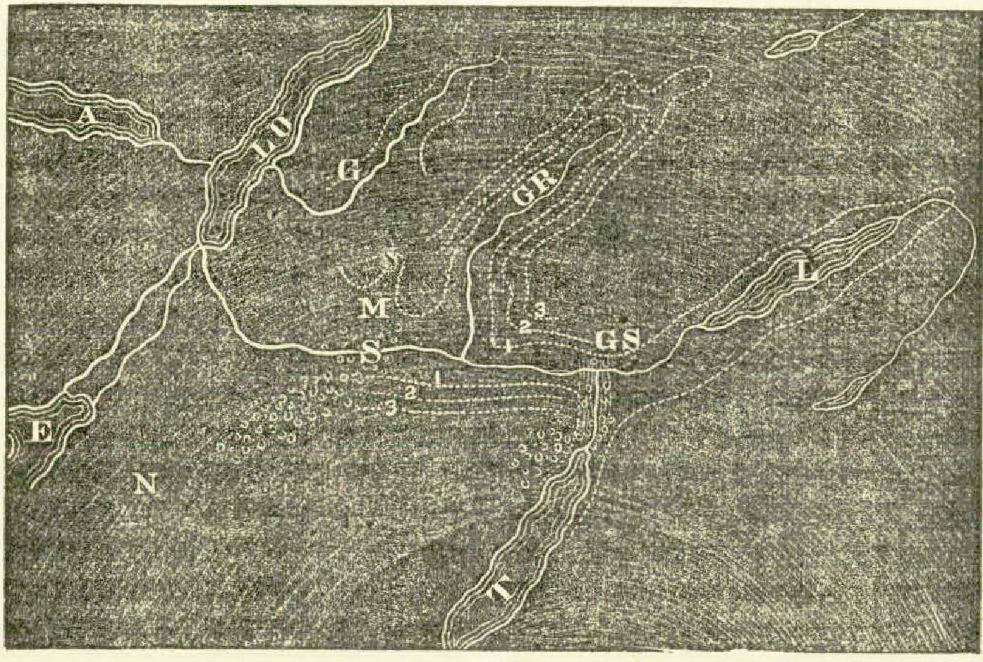
G. R. Glen Roy.
M. Moeldhu Hill.
S. Spean River.
G. S. Glen Spean.
L. Loch Laggan.
T. Loch Treig.
G. Glen Gloy.
L. O. Loch Lochy.
A. Loch Arkeig.
E. Loch Eil.
N. Ben Nevis.
1, 2, 3. The three parallel roads.
Following the glacial indications wherever we could find them in the country about Glen Roy, it became evident to me that the whole western range of the Grampian Hills had once been a great centre of glaciers, that they had come down toward Glen Spean through all the valleys on the mountain-slopes to the north and south of it, so that this valley had become, as it were, the great drainage-bed for the masses of ice thus poured into it laterally, and moving down the valley from east to west as one immense glacier. It is natural to suppose, that, at the breaking-up of the great sheet of ice which, if my view of the case is correct, must have covered the whole country at this time, the ice would yield more readily in a valley like that of Glen Roy, lying open to the south and receiving the full force of the sun, than in those on the opposite side of Glen Spean, opening to the north. At all events, it is evident that at some time posterior to this universal glacial period, when the ice began to retreat, Glen Roy became the basin of a glacial lake such as we now find in the Alps of Switzerland, where occasionally a closed valley becomes a trough, as it were, into which the water from the surrounding hills is drained. In such a lake no animals are found, such as exist in any other sheet of fresh water, and this would account for the absence of any organic remains on the terraces of Glen Roy. But at first sight it seemed that this theory was open in one respect to the same objection as the other. What prevented this sheet of water from spreading east and west in Glen Spean ? If it not only filled Glen Roy, but extended to the southern side of Glen Spean immediately opposite the opening of Glen Roy, what prevented it from filling the whole of that valley also ? In endeavoring to answer this question, I found the solution of the mystery.
The bed of Glen Spean, through its whole extent from east to west, is marked, as I have said, by glacial action, in rectilinear scratches and furrows. This westward track of the main glacier is crossed transversely near the centre of the valley by two other glacier-tracks cutting it at right angles. Upon tracing these cross-tracks carefully, I became satisfied, that, after the surrounding ice had begun to yield, after the masses of ice which descended from the northern and southern slopes of the mountains into Glen Spean had begun to retreat, and to form local limited glaciers, two of those lateral glaciers, one coming down from Ben Nevis on the southwest, the other from Loch Treig on the southeast, extended farther than the others and stretched across Glen Spean.3 These two glaciers for a long time formed barriers across the western and eastern extension of this valley, damming back the waters which filled Glen Roy and the central part of Glen Spean.
Evidently the glacier descending from Loch Treig was the first to yield, for, by the time the Glen Roy lake had sunk to the level of the lowest terrace, the entrance to the eastern extension of the valley must have been free, otherwise the water could not have spread throughout that basin as we find it did; but it would seem that by the time the western barrier, or the glacier from Ben Nevis, was removed, the sheet of water was too far reduced to have left permanent marks of its outflow into the Great Glen, except by disturbing and remodelling the large moraines of the older Glen Spean glacier. There are faint indications of other terraces in Glen Roy, even at a higher level than the uppermost parallel road, owing their origin probably to the short duration of a higher level of the glacier-lake, when the great general glacier had not yet been lowered to a more permanent level determined by a limited circumscription within the walls of the valleys. There are other terraces in neighboring valleys at still different levels, — in Glen Gloy, for instance, where the one horizontal road was no doubt formed in consequence of the damming of the valley by a glacier from Loch Arkeig. Mr. Darwin has seen another in Glen Kinfillen, which I would explain by the presence of a glacier in the Great Glen, the marks of which are particularly distinct about the eastern end of Glen Garry.
The evidence of the ancient presence of glaciers is no less striking in other parts of the Scotch Highlands. Between the southeastern range of the Grampian Hills, in Forfarshire and Perthshire, and the opposite ridge of Sidlaw Hills, stretches the broad valley of Strathmore. At the time when Glen Spean received the masses of ice from the slopes of the western Grampian range, the glaciers descended from the valleys on the southern slope of the southeastern range and from those on the northern slope of Sidlaw Hills into the capacious bed of the valley which divides them. The glacial phenomena of this region present a striking resemblance in their general relations to those of the Alps and the Jura. The Grampian range on the northern side of Strathmore valley occupies the same position in reference to that of the Sidlaw Hills opposite, as does the range of the Alps to that of the Jura, while the intervening valley may be compared to the plain of Switzerland. As from the Bernese Oberland and from the valleys of the Reuss and Limmath gigantic glaciers came down and stretched across the plain of Switzerland to the Jura, scattering their erratic boulders over its summit and upon its slopes at the time of their greater extension, and, as they withdrew into the higher Alpine valleys, leaving them along their retreating track at the foot of the Jura and over the whole plain, so did the glaciers from Glen Prossen and parallel valleys on the Grampian Mountains extend across the valley of Strathmore, dropping their boulders not only on the slopes and along the base of the Sidlaw Hills, but scattering them in their retreat throughout the valley, until they were themselves reduced to isolated glaciers in the higher valleys. At the same time other glaciers came down from the heights of Schihallion on the west, and, descending through the valley of the Tay, joined the great masses of ice in the valley of Strathmore, thus combining with the eastern ice-field, just as the glacier from Mont Blanc and the valley of the Rhone formerly combined in the western part of Switzerland with those of the Bernese Oberland. The relations are identical, though the geographical position is reversed, — the higher range, or the Grampian Hills, lying to the north in Scotland, and the lower one, or the Sidlaw Hills, to the south, while in Switzerland, on the contrary, the higher range lies to the south and the lower to the north. I have alluded especially to Glen Prossen because the glacial marks in that valley are remarkably distinct, the whole bed of the valley being scratched, polished, and furrowed by the great rasp which has moved over it, while the concentric moraines at its lower extremity are very striking. But these signs, so perfectly preserved in Glen Prossen, recur with greater or less intensity in all the corresponding valleys, leaving no doubt that the same phenomena existed over the whole region.
Among the localities of Scotland where the indications of glacial action are most marked is the region about Stirling. Near Stirling Castle the polished surfaces of the rocks with their distinct grooves and scratches show us the path followed by the ice as it moved down in a northeasterly direction toward the Frith of Forth from the mountains on the northwest. To the west of Edinburgh, also, there is a broad glacier-track, showing that here also the ice was ploughing its way eastward to find an outlet on the shore.
The western slope of the great Scotch range is no less remarkable for its glacier-traces. The heads of Loch Long, Loch Fyne, Loch Awe, and Loch Leven everywhere show upon their margins the most distinct glacial polish and furrows, while from the trend of these marks and the distribution of the moraines, especially about Ben Cruachan, it is obvious that in this part of the country the glaciers moved westward and southward. About Aberdeen, on the contrary, they moved eastward, while in the vicinity of Elgin they advanced toward the north.
It thus appears that the whole range of the Grampians formed a great centre for the distribution of glaciers, and that a colossal ice-field spread itself over the whole country, extending in every direction toward the lower lands and the sea-shore. As the glaciers which now descend through all the valleys of the Alps, along their northern as well as their southern slopes, and in their eastern as well as their western prolongation, though limited,in our days, within the valley-walls, nevertheless once covered the plain of Switzerland and that of Northern Italy, so did the ice - fields of the Grampians during the greatest extension of the Scotch glaciers spread over the whole country. They also were, in course of time, reduced to local glaciers, circumscribed within the higher valleys of the more mountainous parts of the country, until they totally disappeared, as those of Switzerland would also have done, had it not been for the greater elevation of that country above the level of the sea. Scotland nowhere rises above the present level of perpetual snow, while in Switzerland the whole Alpine range has an altitude favorable to the preservation of glaciers. In the range of the Jura, however, which had at one time its local glaciers also, but which nowhere now rises above the line of perpetual snow, they have disappeared as completely as in the Grampian Hills.
It would lead me too far, were I to give here a special account of all the investigations I made, in 1840 upon the distribution of glaciers in Great Britain. I will therefore only point out a few of the more distinct areas of distribution. The region surrounding Ben Wyvis formed such a centre of dispersion from which glaciers radiated, and we have another in the Pentland Hills about Edinburgh. In Northumberland, the Cheviot Hills present a glacial centre of the same kind, and in the Westmoreland Hills we have still another. In the last-named locality, the glacial tracks can be followed in various directions, some of them descending toward the northwest from the heights of Helvellyn, others moving southward toward Amblcside. In Wales the same kind of glacial distribution has been observed ; but as Professor Ramsay has treated this subject in full, I would refer my readers to his masterly work for a further account of the ancient Welch glaciers. In Ireland I had also opportunities of making extensive local investigations of glacial action. I observed the centres of distribution in the neighborhood of Belfast, in the County of Wicklow, and in Cavan.
But nowhere are these phenomena more striking than in Fermanagh County about the neighborhood of Enniskillen, and more especially in the immediate vicinity of Florence Court, the seat of the Earl of Enniskillen. On the northern slope of Ben Calcagh are five valleys lying parallel with each other and opening into the valley of Loch Nilly, which runs from east to west at the base of the mountain. A road now passes through this valley, and, where it crosses the mouth of either of the five valleys rising towards the mountain - slope, it cuts alternately through the two horns of a crescentshaped wall which bars the lower end of every one of them. These crescentshaped mounds are so many terminal moraines, built up by the five glaciers formerly descending through these lateral valleys into the valley of Loch Nilly. They bore the same relation to each other as the glaciers de Tour and d’Argentiàre, the Glacier des Bois with the Mer de Glace, the Glacier des Bossons and the Glacier de Taconet, now bear to each other in the valley of Chamouni; and were it not for the smaller dimensions of the whole, any one familiar with the tracks of ancient glaciers might easily fancy himself crossing the ancient moraines at the foot of the northern slope of the range of Mont Blanc, through which the Arve has cut its channel, the valley of Chamouni standing in the same relation to Mont Blanc as the valley of Loch Nilly does to Ben Calcagh.
I have dwelt thus at length on the glaciers of Great Britain because they have been the subject of my personal investigations. But the Scotch Highlands and the mountains of Wales and Ireland are hut a few of the many centres of glacial distribution in Europe. From the Scandinavian Alps glaciers descended also to the shores of the Northern Ocean and the Baltio Sea. There is not a fiord of the Norway shore that does not bear upon its sides the tracks of the great masses of ice which once forced their way through it, and thus found an outlet into the sea, as in Scotland. Indeed, under the water, as far as it is possible to follow them through the transparent medium, I have noticed in Great Britain and in the United States the same traces of glacial action as higher up, so that these ancient glaciers must have extended not only to the sea-shore, but into the ocean, as they do now in Greenland. Nor is this all. Scandinavian boulders, scattered upon English soil and over the plains of Northern Germany, tell us that not only the Baltic Sea, but the German Ocean also, was bridged across by ice, on which these masses of rock were transported. In short, over the whole of Northern Europe, from the Arctic Ocean to the northern borders of its southern promontories, we find all the usual indications of glacial action, showing that a continuous sheet of ice once spread over nearly the whole continent, while from all the mountain - ranges descended those more limited glacial tracks terminating frequently in transverse moraines across the valleys, showing, that, as the general ice-sheet broke up and contracted into local glaciers, every cluster or chain of hills became a centre of glacial dispersion, such as the Alps are now, such as the Jura, the Highlands of Scotland, the mountains of Wales and Ireland, the Alps of Scandinavia, the Hartz, the Black Forest, the Vosges, and many others have been in ancient times.
In the next article we shall consider the glacial phenomena as they exist in America.
- See January No., p. 61.↩
- Having enumerated the characteristic features of the glacial phenomena in the preceding pages, I throw into this note some explanations which may render my views of the parallel roads more intelligible, not to interrupt again the exposition with details. It would be desirable, however, that the reader should first make himself thoroughly familiar with the localities concerned, before proceeding any farther. I would therefore state here, that, in the wood-cut opposite, G. R. indicates the valley of Glen Roy, with the three parallel roads marked 1, 2, 3. Glen Spean is designated by G. S., and the river flowing at its bottom by S. Loch Laggan, out of which the River Spean rises, is marked L. G. indicates Glen Gloy, a little valley to the northwest of Glen Roy, with a single terrace. Loch Treig is designated by T., Loch Lochy by L. O., Loch Arkeig by A,, and Moeldhu Hill by M., while E. indicates Loch Eil. The Great Glen of Scotland, through which the Caledonian Canal runs, extends in the direction of L. O. and E. The position of Ben Nevis is designated by N. The dotted area betwen N. and M. marks the place occupied by the great glacier of Ben Nevis, when it extended as far as Moeldhu; while the close continuous lines in front of Loch Treig indicate the direction of the glacial scratches left across Glen Spean by the glacier of Loch Treig, when it extended as far as the eastern termination of the two upper terraces. It ought to he remembered, in this connection, that the bottom of the valley of the Spean, as well as that of Glen Roy, is occupied by loose materials, partly drift, that is, materials acted upon by glaciers, and partly decomposed fragments of rocks brought down by the torrents, greatly impeding the observation of the polished surfaces. The river-bed is cut through this deposit, and here and there through the underlying rock. Besides the parallel roads, there are also peculiar accumulations of loose materials in Glen Roy and Glen Spean, more particularly connected with the lowest terrace, which Mr. Darwin and Professor Jamieson have shown to be little deltas formed during the existence of the lake of Glen Roy at the bottom of the gullies intersecting the shelves of the upper roads. The outlet for the water at the period during which the second terrace was formed, not known when I visited Glen Roy, has been discovered by Mr. MilneHolme, and also observed by Professor Jamieson. During the formation of the upper terrace, the waters escaped through the westernmost tributary of the River Spey, in the direction of the northeast corner of the woodcut, and during that of the lowest terrace, at the eastern end of Loch Laggan, also through the valley of the Spey. The state of preservation of the parallel roads is such as to prove that no disturbance of any importance can have taken place in the country since they were formed. Far from believing, therefore, that these remarkable shelves are ancient seabeaches, I am prepared to maintain, that, had the area occupied by them been submerged only for a few days, under an ocean rising and falling for several feet with every tide, no vestige would have been left of their former existence.↩
- The wood-cut on p. 730 is a reproduction of the little map accompanying a paper of mine upon “ The Glacial Theory and its Recent Progress,” printed in the “Edinburgh New Philosophical Journal ” for October, 1842. I might have greatly improved the topography, and represented more accurately the details of the phenomenon, by availing myself of the much larger and very minute map recently published by Professor Thomas F. Jamieson, of Aberdeen; but I thought it advisable to leave my first sketch as I presented it twenty-two years ago, in order to show that Sir Charles Lyell is mistaken in ascribing (see “ Antiquity of Man,” pp. 260, 261) the discovery of the glacier of Loch Treig to Professor Jamieson. A comparison of his statements with mine will show that the solution of the problem offered by him is identical with that proposed by me, as he himself candidly admits (“ Quarterly Journal of the Geological Society ” for August, 1863, p. 239). I have only one fault to find with his observations, and, as I have never revisited the locality since, this remark may satisfy hint that my examination of its features was not so hurried as he supposes. Professor Jamieson confounds the effects of two distinct glaciers moving in different valleys as the action of one and the same glacier. In my paper, it is true, I made no allusion to the great glacier of Glen Spean, the existence of which I had recognized along the river from Loch Laggan nearly to the Caledonian Canal. I publish my observations upon this great central glacier for the first time in the present article, having omitted them in my contributions upon this subject to the scientific periodicals of the day simply because I thought best not to complicate my exposition of the facts concerning the parallel roads by considerations foreign to their origin, convinced as I was, from the manner in which the glacial theory was then received, that they would not be understood, and still less admitted. But now that all the geologists of Great Britain seem to have given their adhesion to it, I may be permitted to state that I already knew then, what Professor Jamieson has overlooked in his latest paper, that a separate glacier had occupied the valley of the Spean prior to the formation of the parallel roads, and that at that time the glacier of Loch Treig was only a lateral tributary of the same, just as the glacier of the Thierberg is a tributary of the glacier of the Aar. It was not until the Glen Spean glacier had retreated to the hills east of Loch Laggan that the glacier of Loch Treig could form a barrier across Glen Spean, and thus dam the waters in Glen Boy which produced the parallel roads. The marks left by the great Glen Spean glacier in the valley are mistaken by Professor Jamieson for indications, that, in its greatest extension, the glacier of Loch Treig not only advanced across Glen Spean, but divided into two branches, one moving westward down Glen Spean, the other eastward up Glen Spean, as far as Loch Laggan. Any one sufficiently familiar with existing glaciers to compare their action with the phenomena referred to above will at once see the impossibility of such a course for any glacier coming down from Loch Treig. At the time the Grampians had become a separate centre of glacial action a great glacier must have moved down, towards the Caledonian Canal, through Glen Spean, receiving as tributaries lateral glaciers not only from Loch Treig and Glen Roy, but also from all the other minor lateral valleys emptying into Glen Spean, the largest of which must have come from the range of Ben Nevis,—just as the great glacier of the valley of the Rhone once received as tributaries all the glaciers coming down into that valley from the southern slope of the Bernese Oberland, and from the northern slope of the Valerian Alps, and at one time also from the eastern slopes of the range of Mont Blanc. And when the large glacier occupying the lower, and therefore warmer, level gradually disappeared and retreated far away to levels where it could maintain itself against the effect of a returning milder climate, the opening spring of our era, as we may call it, the lateral glaciers, arising from the nearer high grounds, could extend across the valleys, but not before.↩