The Alaska Boundary Line
“IN endeavoring to estimate its character I am glad to begin with what is clear and beyond question. I refer to the boundaries fixed by the treaty.”
These words form the opening of the magnificent speech of Charles Sumner in the United States Senate in 1867, in advocacy of the ratification of the treaty by which Russia ceded to the United States her entire possessions in America. The distinguished orator, whose address on that occasion was an exhibition of profound historical and geographical research and far-sighted statesmanship which has seldom been equaled, does not appear to have suspected that by coming into possession of the great territory whose purchase he so ably advocated the United States would find itself involved, a quarter of a century later, in two controversies, both with Great Britain, one of which should concern what he then declared to be “ clear and beyond question.”
What is generally known as the “ Bering Sea controversy,” but which might be called with greater propriety the “ fur seal controversy,” has had its beginning, unfortunately not its end, within the last decade. In Sumner’s day nothing was known which indicated the possible existence of conditions such as have given rise to this dispute. It is a little difficult to understand, however, that so able a diplomat as Sumner could have studied the definition of the boundaries of the new territory as found in the treaty of cession without seeing therein the seed of future complications with the English nation. That he began by assuming the boundaries to be “ beyond question ” must have been due in large measure to the fact that, as far as related to the land lines, they were turned over to us exactly as they had been agreed upon by treaty of Russia with Great Britain more than forty years earlier, during which period no controversy over them had arisen. He was aware, of course, of the controversies between Russia and both the United States and Great Britain, in the first quarter of the century, regarding territorial and maritime rights and privileges, but the vagueness, in certain important respects, of the English-Russian treaty of 1825 does not seem to have impressed itself upon him. As a matter of fact, the superior importance of southeast Alaska, which is the only part whose boundary is likely to be in controversy, was not generally recognized at that time, and reliable information about the whole was so scanty that little attention was likely to be given to mere “ metes and bounds.” Since the occupancy of this part of the territory by Americans and its fairly full exploration by government officers, its importance has been admitted by us and recognized by the English to the end that the boundary line dividing it from British Columbia and the Northwest Territory bids fair to become a matter of dispute between the two nations, and one of no mean proportions. Though not of such a nature as to demand immediate settlement, it is not unlikely that it may be involved with two or three other questions at present pending, and about which not only diplomats, but the people generally have been, and are, deeply concerned. The Alaska boundary line is quite worthy of separate consideration on its own account, and it will be a misfortune if any ill-considered act shall result in its being merged with other questions of really less importance, and subjected to the by no means uncertain chances of arbitration.
In the treaty which determined the cession of the Russian possessions in North America to the United States, concluded March 30, 1867, the geographical limits (on the east) of the territory transferred are defined as follows : —
“ The eastern limit is the line of demarcation between the Russian and the British possessions in North America as established by the convention between Russia and Great Britain of February 28, 1825, and described in Articles III. and IV. of said convention in the following terms: —
“ Commencing from the southernmost point of the island called Prince of Wales Island, which point lies in the parallel of 54° 40' north latitude, and between the 131st and 133d degree of west longitude (meridian of Greenwich), the said line shall ascend to the north along the channel called Portland Channel as far as the point of the continent where it strikes the 56th degree of north latitude; from this last-mentioned point the line of demarcation shall follow the summit of the mountains situated parallel to the coast as far as the point of intersection of the 141st degree of west longitude (of the same meridian), and finally, from said point of intersection, the said meridian line of the 141st degree, in its prolongation as far as the Frozen Ocean.
“ IV. With reference to the line of demarcation laid down in the preceding article, it is understood : —
“1st. That the island called Prince of Wales Island shall belong wholly to Russia (now, by this cession, to the United States).
“2d. That whenever the summit of the mountains which extend in a direction parallel to the coast from the 56th degree of north latitude to the point of intersection of the 141st degree of west longitude shall prove to be at the distance of more than ten marine leagues from the ocean, the limit between the British possessions and the line of coast which is to belong to Russia, as above mentioned (that is to say, the limit to the possessions ceded by this convention), shall be formed by a line parallel to the winding of the coast, and which shall never exceed the distance of ten marine leagues therefrom.”
Nearly all boundary-line treaties have been found more or less faulty in construction when subjected to rigorous tests such as are sure to come sooner or later. This is doubtless to be attributed in a great degree to the fact that they are usually framed by politicians rather than by geographers ; the advice of the latter being often ignored. The political diplomat is generally possessed by a single dominant idea in entering into a convention, to which all others must be subordinate, and to the realization of which all other features of the treaty must lead.
The convention of 1824 between the United States and Russia, and that of 1825 between Russia and Great Britain (in which are to be found the boundaryline articles quoted above), were the result of a determination on the part of the two English-speaking nations to break down the Russian Emperor’s ukase of 1821, in which territory extending as low as 51° north latitude was claimed by Russia, as well as complete jurisdiction over nearly all water north of this line, thus threatening the fishing and whaling interests and the carrying-trade of both nations. The limitation of Russian possessions to that part of the coast above 54° 40' north latitude and the granting of certain maritime privileges for a limited time were the principal results sought after and accomplished, and unquestionably little thought was given to the definition of a boundary line which traversed a region esteemed to be of little value, either present or prospective. In consequence of this indifference and the apparent absence of geographical instinct in framing the treaty, we have an agreement through which it is now proposed to “drive a coach and six “ in the interests of the ever aggressive and persistently expanding British Empire.
It is therefore important for intelligent Americans to understand the weakness of the articles of agreement upon which our Alaska boundary claims are assumed to rest. They can best be considered in the order of definition in the treaty.
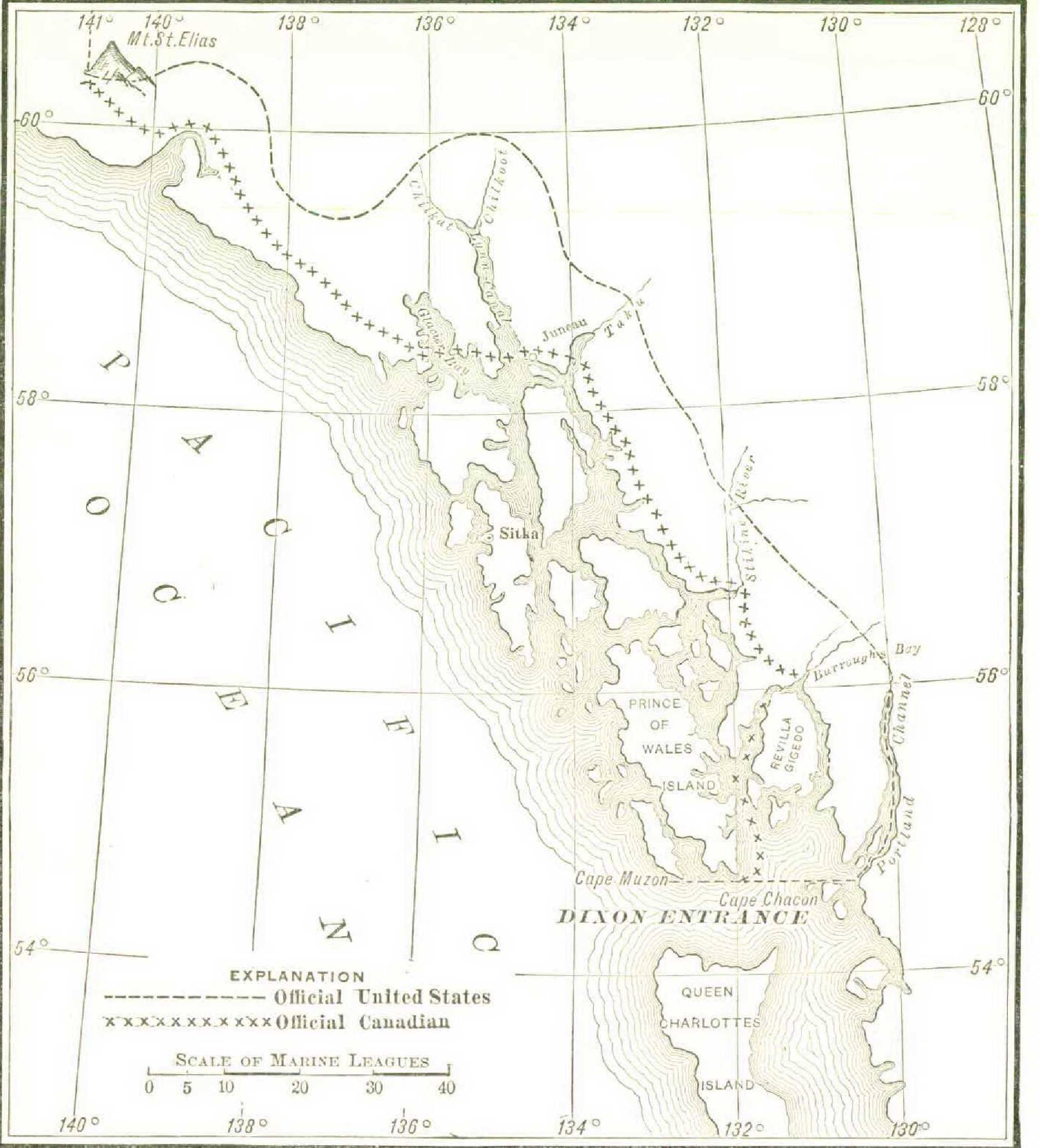
In the first paragraph is found the not uncommon but always unfortunate error of “ double definition,” or rather, in this particular case, of attempting to fix an astronomical position by international treaty. It could not be known in 1825, and, as a matter of fact, it is not now known, that the southernmost point of Prince of Wales Island is on the parallel of 54° 40´ of north latitude, for it is almost absolutely certain not to be on this parallel. No harm comes from this, however, as in a subsequent article (IV.) the possibility of this definition resulting in a divided jurisdiction over the lower extremity of that island is prevented by the provision that the whole island shall belong to Russia (now to the United States). The incident is quite worthy of note, however, as illustrating the claim that the dominant idea was the 54° 40´ line. The prominence of this idea, indeed, in the minds of the several powers was so great as to give rise to the second ambiguity in the boundary-line definition, which follows immediately upon the heels of the first. The description says, “Commencing from the southernmost point ” (Cape Muzon), etc., “the said line shall ascend to the north along the channel called Portland Channel.” Now, an examination of the sketch-map of Alaska, shown above, will make it clear that, beginning with the point of departure as defined above, one must proceed to the east for about fifty miles in order to reach the entrance of Portland Channel, or Portland Canal, as it is often called. On the absence of anything in the treaty in reference to this eastward line has been founded a claim that the use of the name “ Portland Channel ” is an error, an oversight, and that the line was meant to be drawn by turning to the north as soon as possible, which would be after passing Cape Chacon, the easternmost of the two capes at the southern extremity of Prince of Wales Island, and “ascending to the north “ through Clarence Strait and Behm Canal, and finally intersecting the 56th parallel of north latitude in Burroughs Bay. The effect of this would be to throw the whole of the great Revilla-Gigedo Island, together with a large territory between that and Portland Canal (all of which has been almost universally recognized as belonging to Alaska), over to the British side. Preposterous as is this claim, it has for some years received official support at the hands of the Canadian authorities, who have so drawn the line on several of their official maps. It is found on a general map of the Dominion of Canada published by the Interior Department in 1887, and it is drawn in the same way upon what purports to be a copy of an official Canadian map of 1884 (accompanying Executive Document 146, Fiftieth Congress, second session), although an original, now before me, of same date and title, and with which the copy is almost identical in other respects, exhibits the line as following the Portland Canal, in accord with the traditional claims of the United States. In recent English dispatches it has been announced that new facts relating to the treaty have been discovered which greatly strengthen the later Canadian interpretation of this part of the line, but it is hardly to be believed that English diplomats will consider this line in any other light than as affording excellent material with which to “trade” in convention, or on which to “yield ” in arbitration.
On entering the mouth of the Portland Channel, which is struck almost in the centre by the 54° 40´ line, we meet with another claim of comparatively recent date. Just to the north of what must be admitted to be the real entrance to this channel are two considerable islands, Wales Island and Pearse Island. North of these is a narrow, dangerous channel separating them from the mainland, and joining Portland Canal above with the open sea. It is claimed that, admitting Portland Channel, as laid down on the maps, to be the real channel referred to in the treaty, this comparatively narrow passage is a part of it, and the boundary line must be drawn through it so as to put Wales Island and Pearse Island on the Canadian side. This claim is not recognized on the official Canadian map referred to above, dated 1884, but it is upon that of 1887. It can have but little value, except when it comes to the “ general scramble ” which is evidently being prepared for.
The Portland Canal presents another difficulty in the fact that it does not actually reach the “56th degree of north latitude,” as seems to be implied in the language of the treaty, and this has been used as an argument to prove that Portland Channel was not really the channel through which it was originally intended to draw the boundary line. But this canal comes to within a very short distance of the 56th parallel, probably falling short of it by not more than three or four miles, and possibly by not more than a fraction of a mile. The Salmon and Bear rivers debouch into this canal at its head, and the bed of either may represent the extension of the inlet to the 56th parallel. In any event, it is a matter of no great importance, as some sort of hiatus must necessarily exist in a line passing from the level of the sea to the summit of mountains.
Altogether the most serious trouble is to be anticipated in the interpretation of that part of the treaty which defines the line as it is to be drawn from the head of Portland Canal to the 141st meridian of west longitude near Mount St. Elias.
In Article III. the language used is that “from this last-mentioned point” (where Portland Channel strikes the 56th degree of north latitude) “the line of demarcation shall follow the summit of the mountains situated parallel to the coast as far as the point of intersection of the 141st degree of west longitude,” etc. But as there was, apparently, even then a doubt as to the position if not the existence of such a range, the second paragraph of Article IV. was inserted, defining the distance of the line from the winding of the coast, in case the assumed mountain range might be found to run further from the shore than was then supposed. Although most interested in the other features of the treaty, it is evident that British diplomacy, with its accustomed shrewdness, was looking after secondary as well as primary questions, and was by no means disposed to trust to the possible meanderings of any little-known range of mountains, even though drawn upon the map by its own explorers. It was provided, therefore, that while the “ summit of the mountains parallel to the coast ” should furnish the boundary line whenever such line would be ten marine leagues, or less, from the coast, if it should appear in the future that said mountains carried their summits to a greater distance inland, then the line was to be drawn “ parallel to the winding of the coast,” and so as never to “ exceed the distance of ten marine leagues therefrom.” It is important to note that this article may be regarded as containing something stronger than a quasi-admission on the part of Great Britain that the strip of territory conceded to belong to Russia should be in width ten marine leagues from the coast line : it also implies that this is the maximum width to which she will consent, and that there is nothing in the treaty to prevent her making it one league or half a league, if, in the future, she is able to do so and the mountains parallel to the roast do not stand in the way.
When this treaty was made, and indeed until a comparatively recent date, the charts of the region prepared under the direction of Vancouver were the most reliable at hand. One of them (it is likely to have been the French edition) was doubtless before the authors of the articles defining the boundary line. All show a well-defined range of mountains, running nearly parallel to the coast line, and removed from it by a varying distance, sometimes as great as forty miles or more. It is now known, however, and has been known for several years, that the very regular and neatly drawn mountain ranges which Vancouver’s map exhibits owe their origin to the imagination of his draughtsman more than to anything else ; that is, as far as their form goes. Indeed, it is probably just to say that they were intended only as conventional representations of the fact that mountains were seen in almost every direction, and especially in looking from the coast toward the interior. Within the past few years many topographical maps have been executed, and many photographs have been made of these mountains as viewed from the summits of some of those which are accessible. Very excellent views have been obtained from elevations of four thousand and five thousand feet, looking towards the interior and extending far beyond any claim of the United States. These show a vast “ sea of mountains ” in every direction, generally increasing in elevation as the distance from the coast increases. Seen from a distance or from the deck of a ship at sea, they might easily create the impression of a range or ranges “ parallel to the winding of the coast.” As a matter of fact, there is nothing of the kind, but only the most confused and irregular scattering of mountains over the whole territory, at least until the Fairweather range, south of Mount St. Elias, is reached. Of course it is quite possible to draw a series of lines from mountain summit to mountain summit, which would form a line parallel to the coast, or any other assumed line, but no one can deny that the language of the treaty implies a range of summits extending “in a direction parallel to the coast.” As the mountains which actually exist cover the territory down to the water’s edge, the logical application of the mountainsummit definition, if it is to be applied at all, is to draw the line from peak to peak along the seacoast, and this our friends on the other side have not hesitated to do. It is so drawn on the official Canadian map dated 1887, and also by Dr. G. M. Dawson, director of the Dominion Geological Survey, on his map submitted to show proposed conventional boundary lines. Naturally, this line, in common with all recently drawn maps of the Canadian government, practically leaves little to us except the group of islands lying off the mainland. While nominally allowing us a narrow strip, which is perhaps not quite all covered by high tides, it makes several short cuts which serve to break the continuity of our coast line, and to give considerable seacoast to British Columbia.
Against the mountain-summit theory, the contention of the United States is, or should be, that as it is unquestionably proved that no such range of mountains exists as was shown on the charts of Vancouver, and as the high contracting parties evidently had in mind when they agreed to the treaty, it becomes necessary to fall back upon the alternative definition, which places the line parallel to the winding of the coast,” and not more than ten marine leagues distant therefrom. It may be claimed that this was to have application only in localities where the range of “ mountains parallel to the coast ” was more than ten marine leagues from the coast, and that it vanishes when said range disappears. In reply it may be said that there are indications strongly pointing to the actual existence of such a range far beyond the boundary limit towards the interior; but even if it be finally known that no such range exists, either more or less than ten marine leagues from the sea, the intent of the agreement can be distinctly proved ; and in the impossibility of executing one of its provisions, an alternative, specially provided for the failure of that one, must be accepted.
But as soon as we suggest that both the spirit and the letter of the treaty would be satisfied by drawing the line ten marine leagues from the coast, we are met with some astounding arguments as to what is meant by the coast. A wellknown English authority has contended, in effect, that the coast line from which this distance should be measured should be drawn tangent to, and so as to include, the islands lying along the coast. The effect of this would be practically to exclude us from the mainland, and to throw valuable parts of the islands themselves over to the Canadian side. In the face of the plain statement that the line is to be drawn “ parallel to the winding [sinuosités] of the coast,” it is not believed that this point can be seriously urged.
Should it be found possible to project a line satisfactory to both parties, from Dixon’s Entrance, at some point of which it must begin, to the region of the Mount St. Elias Alps, there will be no difficulty in agreeing upon the remainder of the boundary. From the point where it strikes the 141st meridian west longitude it is to be extended along that meridian “ as far as the Frozen Ocean.” Since it is an astronomical line, its position can be ascertained as accurately as circumstances require.
In order to remove a not uncommon but erroneous impression that the Alaska boundary line is now, and has been for some time, in a state of adjudication, it may be well to say that thus far nothing has been done except to execute such surveys as have been thought desirable and necessary for the construction of maps, by which the whole subject could be properly presented to a joint boundary - line commission whenever such should be appointed, and on which the location of the line could be definitively laid down if a mutual agreement should be reached. Such a survey was first brought to the attention of Congress in a message of President Grant in 1872. It was not until 1889, however, that the work was begun by the United States Coast and Geodetic Survey, which sent two parties to the valley of the Yukon, in the vast interior of the territory, with instructions to establish camps, one on that river, and the other on its branch the Porcupine, both to be as near the 141st meridian as possible. These parties were to carry on a series of astronomical observations for the purpose of determining the location of the meridian, to execute such triangulation and topographical surveys as were necessary for its identification, and to establish permanent monuments as nearly as might be upon the meridian line.
They remained at their posts, under stress of weather and other unfavorable conditions, for two years, during which their work was done in a manner quite sufficient for any demands ever likely to be made upon it. The two most important points on the boundary, where it intersects the two great rivers named above, were thus determined, and a year or two later the position of the boundary meridian in relation to the summit of Mount St. Elias was established. It is difficult to see what more will be required for a long time to come, as far as relates to this part of the boundary line. In southeast Alaska, where all the uncertainties as to definition of the boundary line exist, peculiar and in a certain sense insuperable obstacles are met with in the actual survey or “running ” of a line in the ordinary sense. In nearly all of the proposed routes most of the line passes through a region practically inaccessible, or at least not accessible without the expenditure of enormous sums of money and many years of time, wholly disproportionate to the end to be gained. To attempt to make anything like a detailed topographical survey of the wide region covered by the several claims, of sufficient accuracy to satisfy the conditions, and to “ run ” a line wherever it should finally be located, would involve labor and expense impossible to estimate in advance, but sure to be extraordinarily great. In view of these facts, it was determined to make such a survey as would enable a boundary-line commission to fix upon any one of several “ conventional" lines which had been suggested already as satisfactory substitutes for that of the treaty, now generally admitted to be impossible of realization. In July, 1892, an agreement was entered into between the United States and Great Britain for the execution of a joint or coincident survey of this region, for boundary-line purposes. It was agreed by the commissioners appointed to make this survey to carry out, in effect, the plan mentioned above. Astronomical stations were to be established at the mouths of the principal rivers which flow across the boundary line, namely, at the head of Burroughs Bay, the mouths of the Stikine and the Taku, and the head of Lynn Canal. A series of triangles were to be run from these up the river valleys, until a point beyond the probable or passible location of the boundary was reached. Topographical sketches were to be made and a good deal of photographic topography was to be done, especially by the Canadian parties. This plan, which was successfully carried out, received the approval of the Department of State, and the representatives of the two governments coöperated in its execution. It is believed to have furnished all information, besides what had been previously accumulated, necessary to a full discussion and a complete settlement of the controversy. One of the important results of this work has been the accumulation of evidence, if indeed any were needed, of the impossibility of the “mountain-summit” line, and the consequent necessity of falling back upon a line at a measured distance from the coast. That this distance, in accordance with the spirit and intent of the treaty of 1825, should be practically ten marine leagues is apparent from the treaty itself and from contemporaneous history. It was evidently meant to convey, or rather to confirm, to Russia a “ Strip of the coast,” complete and unbroken, from the parallel of 54° 40' north latitude to Mount St. Elias. The word lisière used in the treaty to describe this strip, and which becomes “line” in the English version, means much more than that, being originally equivalent to “border,” “ selvage,” “fringe,” or “ list ” of cloth, always standing for something of very definite width and continuity. Contemporary writers might be quoted, showing a common belief among Englishmen themselves that the treaty accorded to Russia a very definite and continuous strip of the mainland, which, by cutting off direct access to the coast, “ rendered the great interior of comparatively little value.”
In conclusion, the situation may be summed up as follows : —
Our purchase of Alaska from Russia in 1867 included a strip of the coast (lisière de côte) extending from north latitude 54° 40' to the region of Mount St. Elias. This strip was thought to be separated from the British possessions by a range of mountains (then supposed to exist) parallel to the coast, or, in the case of these mountains being too remote, by a line parallel to the windings (sinuosités) of the coast, and nowhere greater than ten marine leagues from the same. As the advantage of an alternative line could hardly have been intended to accrue to one only of the contracting parties, and as Great Britain would benefit by every nearer approach of the alleged mountain range than ten marine leagues, it must be inferred that the spirit and intent of the treaty was to give Russia the full ten leagues wherever a range of mountains nearer to the coast than that did not exist. For more than fifty years there was, as far as is known, no claim on the part of Great Britain to any other than this simple interpretation of the treaty, and up to a very recent date all maps were drawn practically in accord with it. Above all, it is clear, both from the language of the treaty and from contemporaneous history, that the strip of coast was intended to be continuous from the parallel of 54° 40' north latitude. The right of complete jurisdiction over this coast, exercised so long by Russia without protest from Great Britain, became ours by purchase in 1867. Since that date the development of the northwest has shown the great value of this lisière. Its existence has become especially disagreeable to Great Britain, because through its waterways and over its passes much of the emigration and material supplies for her northwestern territory must go. The possession by us of the entire coast of North America north of 54° 40' to the Arctic Ocean is not in itself in harmony with her desire or her policy. The Alaska boundaryline dispute offers an opportunity to break the continuity of our territorial jurisdiction, and by securing certain portions of the coast to herself greatly to diminish the value of the remaining detached fragments to us. The wisdom of this from the Downing Street standpoint cannot be questioned. Those of us who desire to assist in its accomplishment have only to urge the importance of submitting every controversy of this kind, no matter whether we are right or wrong, to the court of arbitration. Arbitration is compromise, especially when two great and nearly equally strong nations are engaged in it. No matter how much or how little a nation carries to an arbitration, it is tolerably certain to bring something away. Once before a board of arbitration, the English government has only to set up and vigorously urge all of the claims referred to above, and more that can easily be invented, and it is all but absolutely certain that, although by both tradition and equity we should decline to yield a foot of what we purchased in good faith from Russia, and which has become doubly valuable to us by settlement and exploration, our lisière will be promptly broken into fragments, and, with much show of impartiality, divided between the two high contracting parties.
It is to be regretted that our share in recent important events has tended to lead us toward this end rather than away from it. We have thrust ourselves into a controversy over a boundary line on another continent, in which we can have no interest, except perhaps that which grows out of a very foggy and uncertain sentiment. We have assumed that a European power is about to “extend its system” to a part of the western continent, or that England is on the point of “ oppressing “ the people of a South American republic, or of “ controlling the destiny" of their government. Against this we have made an active and aggressive protest, and have clearly intimated that it Great Britain does not submit this boundary question to arbitration we shall make trouble. In so doing we have once more put ourselves exactly where far-sighted English statesmanship would have us. Under ordinary circumstances our attitude on this question would be considered as almost an offense, and the channels of diplomatic correspondence would not be as clear and uninterrupted as they now are.
The truth is that Great Britain is meeting our wishes in this matter with almost indecent haste, because the arbitration of the Alaska boundary line, by which she hopes and expects to acquire an open seacoast for her great northwest territories, and to weaken us by breaking our exclusive jurisdiction north of 54° 40', is enormously more important to her than anything she is likely to gain or lose in South America. Having driven her to accept arbitration in this case, it will be impossible for us to refuse it in Alaska, and we shall find ourselves again badly worsted by the diplomatic skill of a people who, as individuals, have developed intellectual activity, manliness, courage, unselfish devotion to duty, and general nobility of character, elsewhere unequaled in the world’s history, but whose diplomatic policy as a nation is and long has been characterized by aggressiveness, greed, absolute indifference to the rights of others, and a splendid facility in ignoring every principle of justice or international law whenever commercial interests are at stake.
T. C. Mendenhall.