Great Dam
I
IN a desert in Egypt has stood for six thousand years the most massive structure ever built by man. In a desert in the State of Washington a new champion arises. The Great Pyramid weighs some 7,000,000 tons — say 120 Queen Marys piled together and squashed solid. The Grand Coulee Dam on the Columbia River already exceeds this total. When it is finished it will weigh 23,000,000 tons, over thrice the heft of Cheops.
One of these masses is built of cut stone, the other of poured concrete. One took 50,000 men twenty years to build, the other will take 5000 men six years, in a task not only three times greater but vastly more complex and dangerous. Both structures relied on the labor of those who would otherwise have been unemployed. Egyptian peasants in the off season built Cheops; American workingmen and engineers shelved by a great depression are building Grand Coulee. Pyramids were houses for the dead. Dams are centres of energy for the living. It is better, I think, to live in the age of the Great Dams than in the age of the Great Pyramids.
Owners of stocks and bonds in utility companies, to judge by their dinner-table conversation, prefer pyramids. It is still too early, however, to calculate the final effect of cheap hydroelectric power on utility earnings. In the Tennessee Valley, to date, power from government dams has so stimulated consumption that some private utilities in the district are doing the best business in their history. The big dams, however, are not primarily power projects, but something more fundamental. In the last hundred years, man has all but wrecked the balance of nature in the North American continent. Flood, drought, dust storms, erosion, the destruction of forest and grass cover, are making hideous inroads on the organic stability of the United States. Some 10,000,000 Americans have already lost their living from natural resources. The chief purpose of the great dams is to restore equilibrium.
In the long run, it will be found that the TVA is not so much a power project as an attempt to replace a declining cotton culture with a more diversified agriculture. The proposed dams in New England and in the Ohio Valley are primarily for flood control. The dams in the far West are concerned with irrigation and water conservation in an area of limited rainfall. The two huge dams of the Central Valley project in California are designed to halt a declining water table, and, by a regulated flow of fresh water, to hold back the salt water of the Pacific, which is seeping in to ruin the rich farm land of the Sacramento delta.
Power companies build dams for one purpose — power. Sometimes the reservoir silts up because erosion on the watershed cannot be controlled, and then there is n’t any more power. I have seen such useless reservoirs in Tennessee and Texas. The federal projects are of a different order altogether. They are coming to be known as multiple-purpose dams. Consider, for instance, the Central Valley project, with one great dam on the Sacramento River in the north, and a second on the San Joaquin in the south. They will serve twelve purposes:
1. Flood control
2. Navigation
3. Irrigation
4. Power
5. Domestic water supply
6. Salt-water seepage control
7. Underground water-table control
8. Fisheries, especially salmon
9. Game conservation
10. Erosion control
11. Reforestation
12. Recreation
The Central Valley of California is one of the richest agricultural areas on earth, but it would be doomed if this project were not undertaken. The water table is dropping alarmingly, the Pacific is coming in. The dams would be dirt cheap at the price if hydroelectric generators were unknown. But if you have a dam and a river anyway, why waste the energy coming over it, especially when much of it will be needed to pump water around the irrigation canals?
Boulder Dam in the Colorado has already saved the lower valley from one disastrous flood. It will supply the Imperial Valley with dependable irrigation; it will supply Los Angeles with drinking water, and it will furnish cheap power in the Southwest. Incidentally, the power is all contracted for, and new generators are being installed to take care of the mounting demand. Meanwhile Lake Mead, backing up 110 miles into the Grand Canyon, is one of the loveliest inland seas in the world, and is surely destined to be a great recreation centre. When I was there in March, cowboys were taking to launches and sailboats.
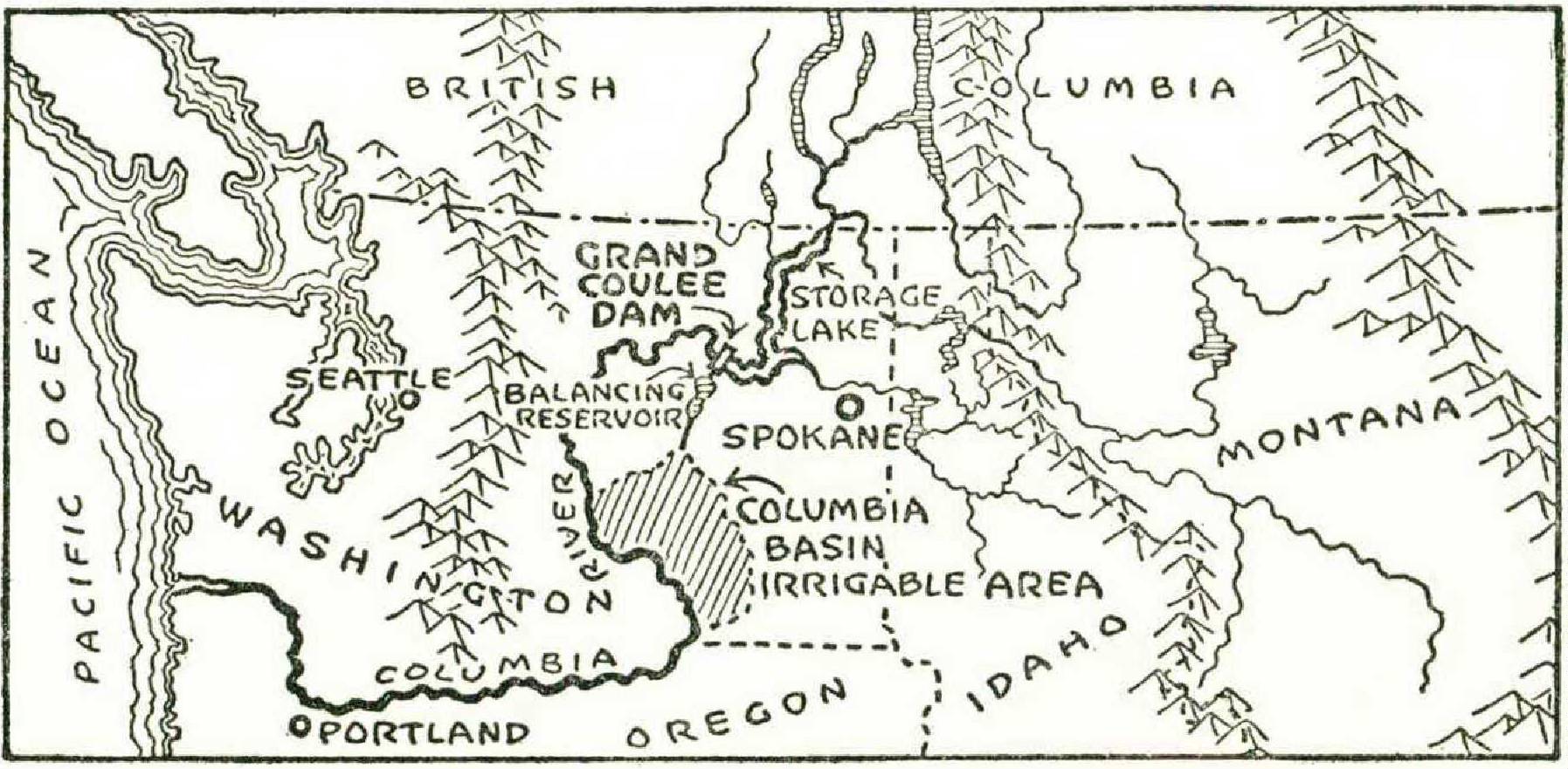
Grand Coulee is primarily an irrigation project. The power will be used to pump water for that project. There will also be power for sale, plenty of it. The dam will control floodwaters down the Columbia 450 miles to the sea. It will deepen the channel between Portland and Bonneville from two to three feet, and thus make navigation on the lower river more dependable. The great lake above the dam, reaching 151 miles to the Canadian border, will be used for fisheries and recreation.
If one looks on these vast and awful structures simply as bones for utility magnates to choke on, he misapprehends the age in which he lives. It is like thinking that the pyramids were built for the view. The utility magnates are not wort h that much attention. These dams will be integrating the economy of a continent when utility magnates, and their quaint financial methods, will be museum and library curiosa, perished from the earth these hundreds of years, along with slums, trade-unions, and contract bridge. Like the Panama Canal, such projects are too vast, they involve too many public interests, to be promoted by private companies. They have to be undertaken by all the people, functioning through the Federal Government.
II
Draw a line on the map from Spokane almost due west to Seattle, a distance of some three hundred miles. A third of the way along lies Grand Coulee, a little to the north of the line, roughly one hundred miles from Spokane, two hundred miles from Seattle, one hundred miles south of the Canadian border.
I reached the site from Spokane by motor in about two hours. We crossed a dry, rolling plain, with a few prosperous farms and the scars of much erosion. It is always difficult for an Easterner to realize that east of the Cascade Mountains, which are not far from the coast, large sections of Washington and Oregon are natural cow country, arid as the Great Plains. The stereotype of the Northwest is a mixture of snowcapped mountains, towering fir trees, leaping waterfalls, and soaking rain. This is true enough of the coast, but one hundred per cent wrong for much of the interior, where you find flat lands, sagebrush, bunch grass, and a ten-inch rainfall. Incidentally these areas, through overgrazing and overploughing for wheat, were rapidly turning into a nice little dust bowl until the men of the Soil Conservation Service went into action.
The sky has that luminous quality you see in the Southwest, but the landscape is not sculptured and painted. Suddenly the plain bursts open! We halt at the rim of a canyon and look down into the depths. At the bottom, one thousand feet below, the Columbia is doing a hairpin turn, twisting from a southwest flow to a northeast flow. The canyon is scarred with mammoth excavations, and just beyond the twist is the clean white line of the dam. This is an urgent river, white-foamed and charging, quite different from the murky, placid Mississippi.
We wind down a steep switchback road to the bottom. Four years ago there was a sheep path here, one sorry little peach orchard, and a crude ferry to take the sheep across to pasture. Charlie Osborne ran the orchard, and Sam Seaton ran the ferry. They constituted the total population of the arid canyon. The walls and river looked much as they did after the last ice sheet moved north.
They look different now. When American engineers move, they move. Government dams may lack the incentive of private profit, but some incentive must have driven the colossal, earthchanging force which has been loosed here. There is a dump pile that could swallow the Empire State Building. There is a conveyor system to carry gravel from the dump pile to the cement mixers, of the general dimensions of Brooklyn Bridge. The mixers would dwarf a Minneapolis grain elevator. There are three distinct towns where as many as 15,000 people have lived — workers and their families.
The dam is low, straight, and shouldered deep into scarred granite walls on either side of the canyon. The river is pouring through a series of cement grooves in the centre, arranged like huge building blocks. To the right and left, the walls are higher, and on the downside the emplacements for the twin power houses have been made ready. On the top of the dam I see an object which looks like a red box for thumbtacks. On closer inspection it turns out to be a standard box freight car. Only then do I begin to grasp the sheer magnitude of the mass.
Most of the work is underwater. The big job has been done. The cofferdams which shunted the river now to the east and then to the west, so that bedrock might be bared and the foundations poured, have accomplished their task and been removed. They were as long as the dam at Muscle Shoals. On the great swelling foundation it now remains to build up the narrower top another three hundred feet; up to those marks on either side of the canyon walls where the big signs are posted: SAFETY PAYS. Pour, pour, pour, for three years more. The big job, the hard job, is done. It took thousands of sweating men; it took forty lives. Nothing like it has ever been accomplished in the world before. Grand Coulee is anchored for millennia in its granite cradle, its joints grouted by cement and water, under high pressure, to form one monolithic mass. Norris Dam is a toy compared to this. Boulder looks more dramatic, arched and deadwhite in its narrower, blue-black canyon; but, for all its greater height, its bulk is only a third as great.
This dam, on the second largest river on the continent, may remain the grandest structure ever built by man for a thousand years to come. It has been designed to take the Columbia at full flood over the upper spillways — one million cubic feet per second, five times the flow of Niagara, and three times the height of the fall. That will be a sight to travel round the world to see! Will she hold? She will. We Americans may be poor hands at shuffling stocks and bonds and credit instruments in a manner to keep the economic structure from collapsing, but, by the eternal, we can build dams.
When one side of the excavation below the cofferdam threatened a major landslide, a quick-thinking engineer worked out a plan to freeze the tumbling earth. Pipes were laid, a refrigerating plant was swiftly built, and the earth was frozen solid until the dam’s foundation was poured and set. When it was found that it would cost several million dollars to haul in agglomerate for the mixers, engineers discovered an adequate supply a mile away in the sloping canyon walls, rigged the most gigantic conveyor system ever heard of, and saved the freight charges. When the river went wild, and the steel cofferdam sprang a serious leak, they threw in a bulldozer — a sort of tractor — to stop the hole until more formal repairs could be brought up.
I have tried to separate visual impressions from statistics. Personally, I prefer my statistics neat. Here is a jigger or two of them: —
| Length of dam at crest | 4,300 ft. |
| Width at base | 500 ft. |
| Width at crest | 30 ft. |
| Height above bedrock | 550 ft. |
| Height above river | 355 ft. |
| Spillway width | 1,650 ft. |
| Generative capacity | 1,890,000 kws. |
| Capacity of each turbine | 150,000 h.p. |
| Annual firm power | 8,320,000,000 kw.-hrs. |
| Annual secondary power | 4,200,000,000 kw.-hrs. |
| Capacity of pumping system | 16,000 cu. ft. per sec. |
| Concrete required | 10,370,000 cu. yds. |
| Excavation | 20,000,000 cu. yds. |
| Length of lake above dam | 151 miles |
| Area of lake | 82,000 acres |
| Capacity of lake | 10,000,000 acre-ft. |
| Balancing reservoir — length | 26 miles |
| Balancing reservoir — area | 27,000 acres |
| Balancing reservoir — capacity | 1,150,000 acre-ft. |
| Elevation of river above sea level | 1,000 ft. |
| Mean annual runoff at dam | 80,000,000 acre-ft. |
| Maximum required for irrigation | 6,000,000 acre-ft. |
| Mean flow | 110,000 cu. ft. per sec. |
| (exceeded only by Mississippi) | |
| Maximum recorded How | 492,000 cu. ft. per sec. |
| Minimum recorded flow | 17,000 cu. ft. per sec. |
| Regulated minimum flow | 35,000 cu. ft. per sec. |
| Drainage area above dam | 113,000 sq. miles |
| (bigger than the United Kingdom) | |
| Cost of dam | $186,000,000.00 |
| Cost of irrigation works | $209,000,000.00 |
Certain of these figures are especially interesting. I said earlier that the dam had been designed to hold a flood of one million cubic feet per second. The greatest flood so far recorded was less than half that total — 492,000 second-feet. In the driest period recorded, the flow was 17,000 second-feet. The dam and reservoir will double this. Hereafter the minimum will be at least 35,000 secondfeet, refreshing the channel, keeping navigation going, keeping the turbines at Bonneville turning down below. The average annual runoff is 80,000,000 acre-feet — meaning eighty million acres of water, one foot deep. At their maximum, the irrigation works will require only 6,000,000 acre-feet, or less than 10 per cent. Secondary power — available only at high-water periods — is about half as much as the firm power, available twenty-four hours a day the year round. The pumps to the balancing reservoir will be operated exclusively on secondary power. While they run, 16,000 cubic feet of water will go tumbling into the reservoir every second. This balancing reservoir is the heart of the irrigation system. Let us take a look at it. The idea goes back to the last ice age.
III
We climb into the car again, and wind up the west canyon wall to the rim. Leading off to the south is another canyon, or coulee, which is dry. The bottom is perhaps seven hundred feet above where the river is now. It is about two miles wide, with sheer rock walls on either side. In the middle is a great mesa called Steamboat Rock. The walls are stained with orange and red lichens, and snow lies in the fissures. This is gaudy scenery, worthy of New Mexico. We follow the canyon down some thirty miles, where it ends in a 400-foot precipice, curved in a great bow three miles wide. These are the famous ‘Dry Falls.’ At the bottom are a few small pools of water, and many rattlesnakes.
What does it all mean? The geologists have carefully worked it out. When the last ice sheet crept south, it forced a huge pile of frozen débris into the Columbia canyon at approximately the site of the present dam. The river rose then as it is rising now, only nature’s dam was higher and the river, fed by a continental ice sheet, was ten times its present volume. The rising waters reached the lip of the old canyon and tumbled out upon the plain, running to the south. In due time they cut the new and higher canyon through which we have just driven. At its end they went over a wall of hard rock and carved the Dry Falls. The volume is estimated at fifty Niagaras. That was a waterfall! For thousands of years it thundered. Then the ice sheet began to shrink. The frozen débris in the old channel melted out. The river, no longer dammed, went back to its ancient course. The great falls went dry.
It is in the higher canyon that the storage reservoir is to be situated. This technically is the ‘ Grand Coulee.’ A 70foot earth dam will be built at either end, stretching from wall to wall. Steamboat Rock will become a flat-topped island. A battery of giant pumps, just behind the river dam on the west side, will lift water from the lower lake up into the Grand Coulee. The vertical distance is 280 feet. The balancing reservoir will then feed the irrigation area off to the south, by gravity canals, of which the longest will run for one hundred miles. Thus men are doing in a smaller way what the Ice Age did in a bigger way — spreading the waters of the Columbia over the plains below the Dry Falls.
Large sections in the arid region of Washington are excellent soil for the dry farming of wheat, notably the Palouse district south of Spokane. The area to be watered by Grand Coulee, with the present eight-inch rainfall, is too dry for any king of farming. The lava soil, however, is very rich. Years ago the tract was opened up and settlers streamed in. They tore up the bunch grass with ploughs, and got fine crops for two or three seasons. Then the surface moisture in the soil was exhausted. The region turned to semi-desert, for after this assault even the faithful bunch grass dried out and died. It is a mournful trip to go about these three counties of Grant, Franklin, and Adams and see the abandoned homesteads, with machinery rusting in the front yard. It was mournful for the settlers to look over the edge of their burning plateau and see the Columbia, carrying unlimited water, five hundred feet below them. No feasible pumping system could get the water up.
After flowing through the dam, the river turns west and then south in a great bend, and forms the westerly boundary of the proposed irrigation area. But to get water into the area the river must be tapped much farther upstream. It was Billy Clapp, eating ham and eggs in a cafeteria in the little town of Ephrata, in 1918, who is credited with solving the riddle. He thumped the table with his coffee cup and proposed to duplicate the geology of the Ice Age. They called him a crackpot until Colonel Goethals, after a careful survey, checked the plan. Hoover and Coolidge then fell into line. It remained for Roosevelt actually to start the dirt flying.
The area to be irrigated is almost as large as Connecticut. It is estimated that two grand canals coming down from the balancing reservoir, one to the west, one to the east, and their feeders, can transform 1,200,000 acres from semidesert to a lush garden spot. The skeptic can cross the river and a few miles to the west see the Yakima Valley, as lush a garden spot as you please, already reclaimed from desert by irrigation. In 1900 there were 13,000 people in the Yakima Valley; now there are 110,000.
First and last, Yakima and many other irrigation projects have had a lot of trouble with land speculators. These fast-moving gentlemen discount the future work of farmer and God, harnessing the former with a staggering debt burden before he plants a crop. At Grand Coulee for once the dirt farmer will get a break. Congress has passed a law forbidding land speculators to practise here. The area will be condemned and valued as desert land. The bona fide settler will pay desert prices — say $7.50 an acre. If he later sells, it must be at desert-land valuation — plus his tangible improvements, of course. The farmer will be charged by the government, without interest, for his share in the irrigation investment, plus his share of the maintenance cost of getting water on his land. A single man will be entitled to not more than forty acres; a family to not more than eighty. A total family investment for land, water costs, house, barn, tools, machinery, electric power connection, has not been determined. Estimates run from $8000 to $10,000.
A well-run irrigation project is agriculture with the weather risk eliminated. No more droughts, no more floods. Water comes to the soil at the time it is needed, especially in the growing season, and in the amount needed. It is almost too good to be true that high water in the Columbia comes precisely during the growing season in June and July. This is the time that the vast Columbia Ice Field in British Columbia, the chief source of the river, begins to melt in earnest. So, when farmers need the water most, the Columbia has it to spare; and when the pumps to the balancing reservoir need power most, a maximum of water is ready to flow down the pentstocks, furnishing cheap secondary power to the giant motors on the pumps.
IV
How about the financial and business aspect? Where is the money coming from? Who’s going to pay for it? Why bring in more agricultural land when farmers all over the country have gone broke because they have produced so much? Who is going to use a billion kilowatts of firm power from the dam — grasshoppers, prairie dogs? If even part of the power is used, what is going to happen to the widows and orphans who have put their hard-earned savings into utility securities?
These are all relevant questions. But a long list can be prepared of questions equally relevant. The impartial conclusion as to the social and economic justification of Grand Coulee can be arrived at only after all the relevant questions have been taken into consideration. For instance; Why do Chambers of Commerce in the Northwest enthusiastically support the project? Why did Goethals, Hoover, and Coolidge favor it? If there are 10,000,000 unemployed persons in the country who should be given work if possible, is it better to put them at building battleships, raking leaves, or constructing new energy stations for food, water, conservation, recreation, and electric power? If men must be fed anyway, is it better to get something useful for the taxpayer’s money, or to get nothing, and let the men rot into the ranks of the unemployables? If investors in private power companies are really damaged, may it not be better to compensate them directly than to deny cheap power to millions of consumers?
What is going to happen to the 100,000 migrants from the dust bowl into the Northwest? Many of them are excellent farmers. Is it better to give them new land for the lands they have lost, and let them at least feed themselves, or to allow them to haunt the bread lines, the relief stations, and the factory doors of the Pacific States, while their families drift from bad to worse? I have seen them. I have talked to them. They want to be given a chance to go to work. They look to these new projects as the Israelites looked to Canaan.
Where are the crop surpluses which cause most of the trouble? In wheat, cotton, corn, and tobacco. What irrigated crops are grown in the Northwest? Apples, pears, nuts, celery, alfalfa, grapes, dairy products, and specialty livestock. Are American consumers surfeited with these products? They are not. They may be surfeited in some areas with hog and hominy, corn pone and sowbelly, but not with apples, celery, tomatoes, butter, and such products rich in vitamins.
Has the consumption of power in the Northwest grown at the rate of 9.5 per cent, compounded annually, in recent years? It has. Is population growing in this area? Owing to one of the greatest migrations in history, it is growing rapidly. Even if the growth rate of power consumption is cut in half, will all of the power from Grand Coulee be absorbed? Every kilowatt-hour, in less than fifteen years. Are there possibilities of new electrochemical industries in the region? In Idaho is the greatest known deposit of phosphate rock on earth. Does increased power use follow a lowering of rates? Almost always. Does the cost of power drop with increased load? Almost always. Is it a good idea to build up more regional self-sufficiency, saving long freight hauls and excessive interdependence? Is it economic to mine ore in Washington and send it to Pittsburgh to be refined, to Bridgeport to be machined, and back to Washington to be consumed as a finished product? Is it wholesome or desirable to have the West and South in perpetual hock to New York?
These, also, are relevant questions. I have indicated some of the answers, but others require more study than they have yet received. Perhaps, on balance, the great dams are not justified by the financial folklore of 1928. Perhaps they are not altogether sound, self-liquidating investments at 6 per cent. But this, sigh as we may, is 1938, and, for better or worse, a different world. Nineteen fortyeight promises to be stranger still. We can never go back to 1928.
We are going hell-bent for somewhere, the like of which, financially, has never been seen before. This is also true of Europe — observe the financial innovations of Dr. Schacht. Concrete dams in granite cradles are solid. They are not like debentures and mortgages, which go up in smoke. Even companies owning skyscrapers go up in smoke, but the steel and concrete never quiver. In a time of disturbing transition, it may not be a bad idea to build solid things which add to the long-range wealth and energy of the people; that reduce flood and drought, water the desert, conserve soil, build up a ‘protective’ food supply, and release great blocks of light, heat, and power.
I may be wrong. Right or wrong, no American can stand below the spillways of the Grand Coulee and not be proud to belong to the nation which could rear this mighty thing.